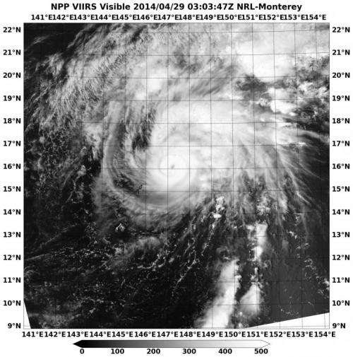
Suomi NPP satellite sees clouds filling Tropical Storm Tapah's eye

NASA-NOAA's Suomi NPP passed over Tapah and captured a visible image of the storm that gave a hint of weakening as clouds began to fill its eye. On April 30 at 0900 UTC/5 a.m. EDT, Tropical Storm Tapah continued to weaken as wind shear began to increase and the storm moved toward cooler waters in the Northwestern Pacific Ocean.
NASA-NOAA's Suomi NPP satellite passed over Tropical Storm Tapah on April 30 and the VIIRS instrument aboard captured a visible image of the storm as it weakened from a typhoon to a tropical storm. The imagery showed that Tapah's eye was becoming cloud filled, but powerful thunderstorms circled the center of the storm.
Tapah's maximum sustained winds were near 55 knots/63.2 mph/101.9 kph as it moved to the north-northwest at 6 knots/6.9 mph/11.1 kph. Forecasters at the Joint Typhoon Warning Center expect Tapah to curve to the northeast as it moves around a ridge of high pressure later today and tomorrow (May 1). Tapah was centered near 19.4 north latitude and 147.1 east longitude, about 457 nautical miles southeast of Iwo To, Japan.
Tapah is expected to become extra-tropical within a day or two as it nears Iwo To.
Provided by NASA's Goddard Space Flight Center


