Penn Museum begins ground-breaking project to create underground image of pre-Inca city
University of Pennsylvania Museum archaeologists working at the ancient site of Tiwanaku in Bolivia-a pre-Inca city sometimes called the "American Stonehenge"--have joined forces with a team of engineers, mathematicians and computer scientists to create a detailed three-dimensional archaeological image of the ruins underneath approximately 60 subterranean acres of Tiwanaku. This three-year project will be applying equipment and techniques that may one day serve as a model for future archaeological efforts worldwide.
University of Pennsylvania Museum archaeologists working at the renowned ancient site of Tiwanaku in Bolivia--a site sometimes called the "American Stonehenge"--have joined forces with a team of engineers, mathematicians, computer scientists and anthropologists from the University of Pennsylvania's Department of Computer and Information Science, School of Engineering, the Center for Advanced Spatial Technologies, University of Arkansas, and the Department of Anthropology, University of Denver, to begin a large-scale, subsurface surveying project using equipment and techniques that may one day serve as a model for future archaeological efforts worldwide.
Their three-year, collaborative pilot project, made possible through a 1.05 million dollar grant from the National Science Foundation, is called "Computing and Retrieving 3D Archaeological Structures from Subsurface Surveying." It seeks to collect detailed, three-dimensional archaeological structural data from approximately 60 subterranean acres of Tiwanaku--without benefit of the archaeologist's trowel.
"What's new, and especially exciting, about this project is how we will be going beyond the employment of geophysical surveys, which archaeologists have been doing with increasing regularity over the last decade," noted Dr. Alexei Vranich, American section Research Associate at the University of Pennsylvania Museum of Archaeology and
Anthropology, a Co-Principal Investigator of the grant and Field Director, with Jose Maria Lopez Bejarano, at the excavations at Tiwanaku since 1995.
"The problem has recently been a kind of 'technological bottleneck,' where large areas are surveyed, but efforts at processing and fusing the data from multiple sensors has slowed the process down considerably. By bringing this level of technological and computer expertise to bear, we should be able to develop a methodology for quickly and efficiently processing the huge amounts of sub-surface data we collect. This will permit archaeologists to develop a far deeper understanding of broad spatial layouts of complex urban sites, like Tiwanaku."
“Our collaboration with anthropologists goes back to two years ago when we started building 3D models of surface structures from camera images,” noted Dr. Kostas Daniilidis, leading Principal Investigator and Associate Professor, Department of Computer and Information Science, University of Pennsylvania. “The scientific challenge in this NSF project is in solving the inverse problem of recovering surface 3D structures from their tomographic projections. We really want to resolve the bottleneck between the huge amount of raw signal data and meaningful information in the form of 3D geometric models.”
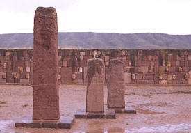
A monumental city in the Bolivian highlands 13,000 feet above sea level and one of 754 recognized World Heritage Sites, Tiwanaku is surrounded by mountain ranges, with Lake Titicaca on its west side. The massive, solid blocks of a stone not indigenous to the flat plateau give rise to the site's nickname, "the Stonehenge of the Americas"--and, over the years, they have given rise to some otherworldly theories of how the site came to be.
In the last 10 years, teams of archaeologists from the University of Pennsylvania Museum and elsewhere have made progress understanding this enigmatic site, and more is being uncovered every year. Archaeologists have concluded that the ancient city was occupied between A.D. 500-1000, then abandoned hundreds of years before the arrival of the Inka in the 15th century. Due to the harsh climate that eroded all the adobe walls of this planned city, and the loss of surface stone harvested by local peoples over the years for later constructions, much of the earlier surface construction has been lost. The loss of surface data, and the large size of the site, estimated at about four square miles, have made it especially difficult for archaeologists to deepen their understanding of the spatial organization of this complex site. Work funded by the National Science Foundation grant will begin in June of 2005, and continue for six weeks every summer through
2008.
Principal investigators working with Dr. Vranich and Dr. Daniilidis include: Dr. George Biros, Assistant Professor, Departments of Mechanical Engineering & Applied Mechanics and Computer and Information Science, University of Pennsylvania; Dr. Jianbo Shi, Assistant Professor, Computer Information Science, University of Pennsylvania; Dr. Lawrence Conyers, Associate Professor of Anthropology, University of Denver, Colorado; and Dr. W. Fredrick Limp, Director for the Center for Advanced Spatial Technologies and Professor, Departments of Anthropology, GeoScience and Environmental Dynamics, University of Arkansas, Fayetteville.
For more information on the Tiwanaku excavations, visit the Museum's Tiwanaku website.
Source: University of Pennsylvania


