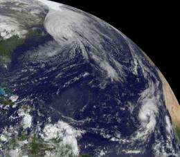
Hurricane watches up in Canada as the GOES-13 Satellite sees Hurricane Igor still expanding

Hurricane Igor may be changing into an extra tropical storm and losing his warm core of energy, but he hasn't lost his punch as hurricane watches are up today in eastern Canada. The GOES-13 satellite captured a look at Hurricane Igor this morning, and noticed the storm continues to grow larger and part of that expansion is likely a result of absorbing Julia's remnants.
The Geostationary Operational Environmental Satellite or GOES-13 is stationary in its position in space, watching over the weather in the eastern U.S. GOES-13 captured a visible satellite image of Hurricane Igor at 1145 UTC (7:45 a.m. EDT) today, Sept. 21 and the image showed Igor's huge size has continued to grow even larger over the last couple of days. Hurricane Igor is now about now 920 miles in diameter!
GOES-13 is operated by the National Oceanic and Atmospheric Administration, and images are created by NASA's GOES Project, located at NASA's Goddard Space Flight Center, Greenbelt, Md.
Igor is quickly losing tropical characteristics today and is transforming from a warm core system to a cold core system, just like typical low pressure systems in the northern hemisphere.
Igor's center was passing near Newfoundland at 11 a.m. EDT morning. As Igor moves north, a hurricane watch is in effect for the coast of Newfoundland from Stones Cove Northward and Eastward to Fogo Island and a Tropical Storm Warning is in Effect for the coast of Newfoundland from Burgeo Northward and Eastward to Triton and the islands of St-Pierre and Miquelon.
Hurricane Igor is maintaining hurricane strength with maximum sustained winds near 75 mph as he continues to track north. Hurricane-force winds extend 85 miles from his center, and tropical-storm force winds extend out to 460 miles, so his diameter has grown to a massive 920 miles!
At 11 a.m. the center of Hurricane Igor was located 35 miles south of Cape Race, Newfoundland, Canada, near 46.2 North and 52.8 West. Based on observations from southeastern Newfoundland this morning, Igor's minimum central pressure was 952 millibars. Igor is moving northeast at 46 mph and is forecast to turn to the north-northeast and then turn north on Wednesday as he continues to move into the cooler waters of the North Atlantic Ocean. Igor is forecast to become a strong extratropical cyclone later in the day.

Additional rainfall accumulations of 1 to 3 inches are possible over eastern Newfoundland today, totaling as much as between 4 and 8 inches of rainfall there from Igor. According to the National Hurricane Center, Canadian buoy 44139 located about 150 miles west of the center reported sustained winds of 62 mph (100 Km/hr) this morning, and Canadian buoy 41138 located just east of the center reported a pressure of 962 millibars.
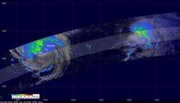
On Sept. 15, Julia and Igor had both been powerful category four hurricanes but Julia's wind speeds had continued to drop since because of wind shear from monster hurricane Igor's outflow. By 11 a.m. EDT on Sept. 20, the National Hurricane Center issued their final warning on Julia. She was 1,100 miles west of the Azores near 34.7 North and 46.4 West and maximum sustained winds were near 46 mph, but quickly weakening. Julia had later been downgraded into a low pressure system and is now in the 2010 Atlantic Hurricane Season history books. Meanwhile, Igor's life history is not finished as he makes a track further into the North Atlantic Ocean.
Provided by NASA's Goddard Space Flight Center


