NASA sees Depression Nine become Gaston then back to a depression

Tropical Depression Nine strengthened yesterday into Tropical Storm Gaston, but today it ran into dry and stable air and weakened back into a depression again.
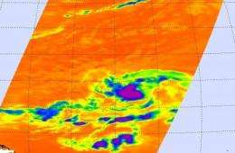
When NASA's Aqua satellite flew over Gaston early this morning, Sept. 2 at 0423 UTC (12:23 a.m. EDT), the infrared image taken from the Atmospheric Infrared Sounder (AIRS) instrument showed that Tropical Depression Gaston seemed to have a compact circulation with some high, cold thunderstorm cloud tops around its center of circulation. Those clouds reached so high into the troposphere that they were colder than -63 degrees Fahrenheit. Later this morning, Gaston encountered some stable and drier air, weakening it back to a tropical depression.
Visible and infrared satellite imagery late this morning showed deep convection (rapidly rising air that forms thunderstorms that power the cyclone) had decreased considerably since the AIRS image was captured, and convection and is limited to a broken band over the western and northern part of the circulation.
At 11 a.m. EDT today, Gaston's maximum sustained winds were near 35 mph, although some re- strengthening is possible as it moves into a better environment. The center of Tropical Depression Gaston was about 970 miles west of the southernmost Cape Verde Islands, or about 1500 miles east of the Lesser Antilles near latitude 14.0 north and longitude 38.9 west. The depression is moving toward the west-northwest near 7 mph and should continue in that direction for the next couple of days. Estimated minimum central pressure is 1008 millibars.
Even though Gaston is in an area of warm waters and upper level winds that will allow it to develop, the dry and stable air is keeping it weak, so re-strengthening is likely to be a slow process. For now, it is no threat to land.
Provided by NASA's Goddard Space Flight Center


