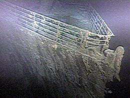
Mapping of 'Titanic' wreck begins

A high-tech expedition that aims to create a detailed map of the wreckage of the Titanic has begun exploring the ocean floor where the ship sank nearly one hundred years ago, the crew said Thursday.
Sonar onboard an automated submersible vehicle combined with high-resolution video will be used to create three dimensional images of the fabled oceanliner.
The expedition, organized by the American group RMS Titanic, which holds exploration rights for the wreck, arrived on Wednesday aboard the scientific vessel Jean Charcot and started by laying flowers on the water's surface to commemorate the 1,500 victims of the shipwreck.
Transponders were then deployed at the bottom of the Atlantic to determine, with the help of sonar pings from an automated underwater vehicle (AUV), the exact position of the Titanic.
Finally, the AUV "Mary Ann" was deployed at 0647 GMT. She reached the bottom after diving for an hour and 40 minutes.
"Surveying of the Titanic wreck site has begun," said the expedition on its website.
Another robotic submersible equipped with a video camera will be deployed next.
Christopher Davino, president of RMS Titanic, said in a statement that the goal is to "create the most detailed portrait of Titanic's wreck site to date."
The team of experts, he said, "will be using some of the most advanced technology available to create a portrait of the ship unlike any that has been created before -- virtually raising Titanic and sealing her current state forever in the minds and hearts of humanity."
The mission, which set sail from St John's, Newfoundland, will provide real-time video and photo updates on Facebook and Twitter during a more than 20-day expedition.
Other images and information will be found on the mission's website, www.expeditiontitanic.com.
The Titanic, a luxury passenger ship once thought to be unsinkable, hit an iceberg on April 14, 1912 and sank in the early morning of April 15, 1912, killing 1,500 people.
After decades of searching, the wreckage of the Titanic was discovered in 1985 some four kilometers (2.5 miles) beneath the surface of the sea.
(c) 2010 AFP


