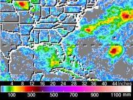
NASA's TRMM satellite maps flood potential as TD5's remnants keep soaking Louisiana, Mississippi

Tropical Depression Five (TD5) may not be a tropical depression anymore, but NASA's TRMM satellite has noticed that its remnant low pressure circulation is making for a very bad and wet Friday the 13th for residents from southeastern Louisiana east to the Florida panhandle.
Even when a tropical system gets downgraded into a low pressure area, there is still the possibility of inland flooding from heavy rainfall, and that's what this low is creating.
The Tropical Rainfall Measuring Mission (TRMM) has been called a "rain gauge in space" and can provide accurate measurements of rainfall in tropical and sub-tropical areas around the world. TRMM data, along with information from other satellites, allows researchers to see how much rain is falling over most of the world every three hours and map areas of potential flooding. Maps that show areas of potential floods use precipitation radar data and high resolution measurements of water content of clouds made by microwave radiometers.
Those rainfall maps were made into a nine day "movie loop" that allows users to track storms as they travel over land and oceans around the globe. The rainfall animations are developed in the Laboratory for Atmospheres of the NASA Goddard Space Flight Center, Greenbelt, Md. by the TRMM precipitation research team.
The TRMM animated flood map from August 4 to August 13 shows the track and development of three tropical systems: TD5, Estelle (in the eastern Pacific) and Colin (in the Atlantic). The animation shows TD5 formed on August 10 as "System 94L" and became Tropical Depression 5 on August 11. On August 13 in the animation, southeastern Louisiana is mapped in yellow indicating the potential for flooding.
On Friday, August 13, the center of tropical depression five's (TD5) remnants were located over the Gulf of Mexico stretching from southeast Louisiana, east to the Florida panhandle. TD5's remnants have already generated up to five inches of rainfall in portions of southeastern Louisiana since Thursday morning, according to the National Weather Service.
TD5's remnants are moving very slowly, and that means more heavy rainfall for those areas today, August 13. As a result, a Flash Flood Watch is in effect for portions of southeastern Louisiana and coast Mississippi through 7 p.m. CDT today.
The flash flood watch includes the following Parishes in southeast Louisiana: Assumption, Lower Jefferson, Lower Lafourche, Lower Plaquemines, Lower St. Bernard, Lower Terrebonne, Orleans, St. Charles, St. James, St. John the Baptist, St. Tammany, Upper Jefferson, Upper Lafourche, Upper Plaquemines, Upper St. Bernard and Upper Terrebonne. In Southern Mississippi the watch covers Hancock, Harrison, Jackson and Pearl River counties.
The National Weather Service noted that between one and two more inches of rainfall, with isolated amounts of up to five inches are possible in the watch areas today. Along the coast, tides are expected to be a foot above normal, and coastal flooding is not anticipated.
Provided by NASA's Goddard Space Flight Center


