Image: NASA Satellite Imagery Keeping Eye on the Gulf Oil Spill

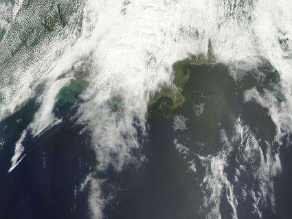
(PhysOrg.com) -- NASA's Terra satellite flew over the Deepwater Horizon rig's oil spill in the Gulf of Mexico on Saturday, May 1 and captured a natural-color image of the slick from space. The oil slick resulted from an accident at the Deepwater Horizon rig in the Gulf of Mexico.
The Moderate Resolution Imaging Spectroradiometer (MODIS) instrument on NASA’s Terra satellite captured a natural-color image. The oil slick appeared as a tangle of dull gray on the ocean surface, made visible to the satellite sensor by the sun’s reflection on the ocean surface. On May 1, most of the oil slick was southeast of the Mississippi Delta.
On Sunday, May 2, NOAA restricted fishing in federal waters of the Gulf of Mexico from the mouth of the Mississippi to Pensacola Bay for at least ten days.

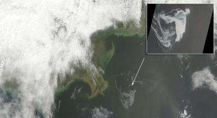
The inset image was captured by the highest-resolution instrument aboard NASA's Terra spacecraft, the Advanced Spaceborne Thermal Emission and Reflection Radiometer (ASTER).
On April 20, 2010, an explosion destroyed the Deepwater Horizon oil platform operating in the Gulf of Mexico 80 kilometers (50 miles) offshore, resulting in substantial loss of life and releasing 5,000 barrels of oil per day into the water. The huge oil slick was being carried towards the Mississippi River Delta, and was expected to reach the Louisiana, Alabama, and Mississippi shores as early as Monday, May 3.
The ASTER image is located at 29.0 degrees north latitude, 88.3 degrees west longitude and covers an area measuring 79.1 by 103.9 kilometers (49 by 64.4 miles), about 32 kilometers (20 miles) west of the mouth of the Mississippi River delta. No land is visible in the image.
The varying shades of white in the image reflect different thicknesses of oil (the whiter, the thicker the oil). The source of the oil spill is visible as the bright white area in the bottom center of the image. The thickest part of the spill extends vertically from it, appearing somewhat like the ash plume of an erupting volcano. The wispy patterns of the oil spill reflect the transport of the oil by waves and currents.
Provided by JPL/NASA


