Tropical Storm Robyn nested away from land

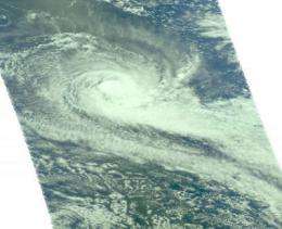
Tropical Storm "Robyn" didn't have to fly south for the northern hemisphere winter, like the birds (Robins), it formed in the southern hemisphere this past weekend in the Southern Indian Ocean. Infrared satellite imagery from NASA's Aqua satellite revealed that the storm's strong thunderstorms and heavy rainfall are safely "nested" over open waters.
Formerly tropical depression 23S, Robyn strengthened into a tropical storm this weekend. As of Monday, April 5, Robyn had maximum sustained winds near 60 knots (69 mph) gusting to 75 knots (86 mph). It was located about 370 nautical miles southwest of Cocos Islands, Australia, near 16.1 South and 92.0 East. Robyn was moving south-southeast at 7 mph (6 knots) and as it moves it is kicking up waves up to 18 feet high.
The Cocos Islands and Keeling Islands, also called the Territory of Cocos (Keeling) Islands, is an Australian territory. There are twenty-seven coral islands and two atolls in the group of islands.
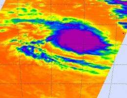
NASA's Aqua satellite has been flying over Tropical Storm Robyn since it developed on Friday, April 2. The Atmospheric Infrared Sounder (AIRS) instrument captured infrared imagery of the storm that showed high, cold, thunderstorm cloud tops as cold as -63 Fahrenheit (-52 Celsius). That data helped forecasters see that Robyn had powerful rain-making thunderstorms. AIRS provided valuable infrared data on Robyn's cloud top temperatures, which are important because they tell forecasters how high thunderstorms are and the rule is: the higher the thunderstorm, the more powerful the tropical cyclone. AIRS imagery revealed this morning that deep convection (rapidly rising air that condenses and forms thunderstorms that power a tropical cyclone) has decreased. Meanwhile, the low-level center of circulation continues to remain well-organized and the strongest winds are in the southwestern quadrant of the storm.

The Joint Typhoon Warning Center noted that Robyn's movement southeastward is taking the tropical storm further into an area of higher vertical wind shear (which can weaken and tear the storm apart). As a result, Robyn is expected to weaken over the next three days while remaining at sea.
Provided by NASA's Goddard Space Flight Center


