NASA satellites see Ida spreading out before landfall

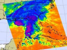
NASA's Aqua and Terra satellites are keeping a close eye on Tropical Storm Ida, and both have instruments aboard that show her clouds and rains are already widespread inland over the U.S. Gulf coast states. Infrared NASA satellite imagery revealed that Ida lost the "signature shape" of a tropical cyclone, and that the storm's clouds have already spread far to the north (over land) of its center of circulation.
At 4 p.m. EDT on November 9, Tropical Storm Ida's maximum sustained winds were near 70 mph. Tropical storm force winds extend outward up to 200 miles from the center. Ida was located near 28.4 North and 88.5 West. That's about 60 miles south-southeast of the mouth of the Mississippi River and about 165 miles south-southwest of Pensacola, Florida. Ida is moving north near 18 mph, and is expected to turn to the east after landfall. Minimum central pressure is 991 millibars. Tropical storm force winds extend outward up to 200 miles from the center.
The Atmospheric Infrared Sounder (AIRS) on NASA's Aqua satellite captured cold thunderstorm cloud tops of Ida in an infrared image at 1:47 p.m. EDT on November 9. The image showed Ida's clouds and rains have spread over Louisiana, Mississippi, Alabama, Tennessee, Georgia and Florida as its center approaches the coast.
The infrared imagery revealed that the cloud tops are not as cold as they were (colder than -63 Fahrenheit) when Ida was a hurricane, indicating Ida has weakened.

In addition to satellite imagery showing that Ida's center is shifting, the National Hurricane Center's last hurricane hunter aircraft fix showed the 700 millibar and surface centers of Ida coming apart, or "decoupling." If you think of a tropical storm link the children's spring toy, "Slinky," the top part of the spring would be leaning over the bottom.
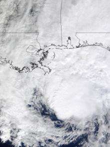
The Moderate Imaging Spectroradiometer instrument on NASA's Terra satellite also provided a visible image of Tropical Storm Ida's cloud cover as she was approaching the U.S. Gulf coast at 12:15 p.m. ET today, and showed the cloud cover spreading out.
Tropical storm warnings are still in effect from Grand Isle, Lousiana to Aucilla River, Florida, including New Orleans and Lake Pontchartrain. Rainfall is still expected between 3 to 6 inches, with up to 8 inches in areas from the Gulf Coast northward into the eastern Tennessee Valley and the southern Appalachians.


