Mirinae intensifying while moving away from the northern Marianas

Typhoon Mirinae is moving west and away from the Northern Marianas Islands on a track to a landfall in the Philippines by the weekend. As Mirinae has moved west, NASA's infrared and microwave satellite imagery have seen high, strong thunderstorm development, and a developing eye.
Typhoon Mirinae's maximum sustained winds are now up to 98 mph (157 km/hr), and its center is approximately 930 nautical miles (that's 1,070 miles or 1,722 kilometers) east of Manila, Philippines. The coordinates of its center are 16.2 North latitude and 136.9 East longitude. Mirinae is moving west at 17 mph.
Tropical storm-force winds extend out to 100 miles from Mirinae's center, while typhoon/hurricane-force winds extend 20 miles out from its center. Mirinae is stirring up waves up to 22 feet high.
Mirinae is intensifying in part because of "strong radial outflow and warm sea surface temperatures," according to forecasters at the U.S. Navy's Joint Typhoon Warning Center (JTWC). JTWC is the organization that forecasts storms in the Western Pacific Ocean. Radial outflow is important in a tropical cyclone development because it spreads ice particles outward from the center of the storm, spreading clouds and precipitation. Basically it helps the storm grow larger.

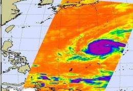
The Atmospheric Infrared Sounder (AIRS) instrument on NASA's Aqua satellite captured a microwave and infrared image of Mirinae on October 28 at 12:35 a.m. local Asia/Manila Time.
The infrared imagery revealed that the cloud tops of Mirinae are close to the top of the troposphere. That means they are strong thunderstorms, where temperatures are colder than -63 Fahrenheit.
AIRS data is also coupled with data from the Advanced Microwave Sounding Unit (AMSU) that flies with AIRS on Aqua to create microwave images of storms. The AMSU image uses the radiances of the 89 GHz channel, and the cold areas in those images indicate where there is precipitation or ice in the cloud tops.
Mirinae has intensified steadily and will continue to do so until landfall in the Philippines on Saturday. Landfall in Luzon between the cities of Soliven and San Jose is still expected to occur around 0600 UTC (2 a.m. EDT, 2 p.m. Asia/Manila local time) on Halloween.
Source: NASA/Goddard Space Flight Center


