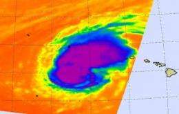
NASA satellite still sees heavy rainfall in Tropical Storm Neki

Tropical Storm Neki continues moving north and over the weekend it will be in open waters in the Central Atlantic. NASA's Tropical Rainfall Measuring Mission (TRMM) satellite passed over Neki early on October 23 and noticed some intense areas of rainfall, even though it is not a hurricane anymore.
On Friday afternoon, October 23, a Tropical Storm warning was still effect for The Papahanaumokuakea National Monument from Nihoa Island to French Frigate Shoals to Maro Reef.
On October 23 at 11 a.m. EDT (5 a.m. HST), Neki had maximum sustained winds near 70 mph. It was moving north-northeast near 7 mph, and had a minimum central pressure of 995 millibars. Its center was about 90 miles south-southeast of French Frigate Shoals and 400 miles west of Lihue, Hawaii near 22.8 North and 165.6 West.
The French Frigate Shoals is the largest atoll in the northwestern Hawaiian Islands. It got its mane name from the French explorer Jean-François de La Pérouse, who almost lost two frigates when attempting to navigate the shoals.
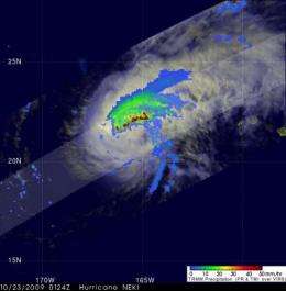
The Tropical Rainfall Measuring Mission (TRMM) satellite, managed by NASA and the Japanese Space Agency (JAXA) passed over Tropical Storm Neki on October 23 at 0124 UTC (9:24 a.m. EDT Oct. 22) and captured a look at Neki's rainfall. TRMM found that areas of heavy rainfall continued to fall in the northeast and the northern quadrants of the storm. Rainfall rates were very intense, around 2 inches (50 millimeters) per hour in those areas of Neki. Because rainfall is so intense, the Central Pacific Hurricane Center is calling for rainfall amounts between 8 and 12 inches in Neki's path over the weekend.

Rain rates are created from different instruments aboard TRMM. The rain rates in the center of TRMM images are derived from the TRMM Precipitation Radar, the only spaceborne radar of its kind, while those in the outer portion are from the TRMM Microwave Imager. The rain rates are then overlaid on infrared data from the TRMM Visible Infrared Scanner to create the entire image. The images are created at NASA's Goddard Space Flight Center, in Greenbelt, Md.
Hal Pierce of NASA's TRMM Team at NASA Goddard also created an animation of rainfall laid over cloud cover (see above).
High seas and large surf will continue to impact portions of the Papahanaumokuakea National Monument Friday and Friday night.
Neki and is expected to continue weakening while moving toward the north-northeast over the weekend.


