Come together, right now... tropical depression 18W dissipates, Parma intensifies

Two tropical cyclones in the Western Pacific are keeping in tune to the 1969 hit song by the Beatles, "Come Together." Tropical Depression 18W and Tropical Storm Parma are already beginning to merge now that 18W made landfall in Guam and dissipated. 18W did bring gusty winds and heavy downpours to Guam, and will continue to affect the surf over the next day or two.
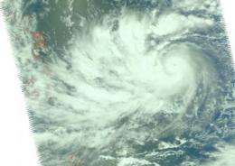
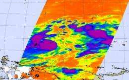
NASA's Aqua satellite flew over the two storms and captured them in one image (because they're close to each other). Parma is located west of 18W's remnants. The Atmospheric Infrared Sounder (AIRS) instrument on Aqua noticed high thunderstorms in Parma as cloud top temperatures were colder than -63 Fahrenheit, and Parma intensified into a typhoon. In 18W, satellite data showed warmer cloud top temperatures, indicating a much weaker system. AIRS captured an image of both storms on September 30 at 1:11 a.m. (Guam local time).
At 11 a.m. local time on September 30, 18W's center was 85 miles east-southeast of Guam. At that time, it had not yet made landfall and was headed toward Guam (Guam is 14 hours ahead of U.S. Eastern Daylight Time). 18W then made landfall in Guam in the afternoon hours (local time) on September 30, and has since weakened into a remnant low pressure area.
The U.S. Navy's Joint Typhoon Warning Center issued its final warning on 18W at 7 p.m. local time (5 a.m. EDT) today, after 18W had made landfall and crossed back into the Western Pacific Ocean. At that time, 18W's center 55 miles west-northwest of Guam, near 13.9 north and 144.0 east and its maximum sustained winds were down to 15 knots (17 mph). 18W's remnants were moving west-northwest near 21 knots (24 mph). That's going to bring the remnants toward Tropical Storm Parma quickly, causing Parma to absorb 18W's leftover energy.

At 7:30 p.m. Guam local time (9:30 a.m. EDT) on September 30 there were High Surf Warnings up for Guam, the Marianas Islands, and Micronesia until 6 p.m. (local time) on Thursday. The National Weather Service noted, "Large swells generated by tropical storm 18w before it weakened to a tropical depression will generate high surf on east facing reefs through Thursday afternoon. A high surf advisory means that high surf will affect exposed reefs and beaches in the advisory area producing dangerous rip currents. Expect hazardous surf of 10 to 12 feet Thursday on east facing reefs. The surf should subside below hazardous levels by Thursday evening."
Guam also posted a Small Craft Advisory in effect until 6 p.m. CHST (local time, Guam) on Thursday. A small craft advisory means that seas 10 feet or greater and sustained winds or frequent gusts of 22 knots (25 mph) or higher are expected to produce conditions hazardous to small craft.
As 18W dissipated, Tropical Storm Parma intensified into a typhoon. Typhoon Parma is located to the west of 18W's remnants, but close enough to draw its leftover energy.
On September 30 at 11 a.m. EDT (3 a.m. local time on October 1), Typhoon Parma had sustained winds near 75 knots (86 mph) and was moving west-northwest near 15 knots (17 mph). It was located about 160 miles north-northwest of the island of Palau. Tropical storm-force winds stretch out to 75 miles from the center, while typhoon/hurricane-force winds extend only 10 miles from the center. Meteorologists at the Philippine Atmospheric Geophysical and Astronomical Services Administration (Pagasa) are calling Typhoon Parma "Pepeng" in the Philippines.
On the current forecast track, Typhoon Parma will not make landfall in the northern Philippines, but its center will remain at sea as it passes to the northeast over the next several days. Because residents of the northern Philippines are still coping with the floodwaters generated from Tropical Depression Ondoy (Ketsana), another tropical cyclone is the last thing they need.
Source: NASA/Goddard Space Flight Center


