NASA's Aqua satellite catches 2 views of super Typhoon Choi-Wan

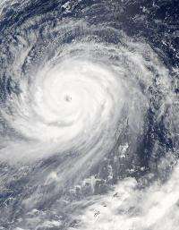
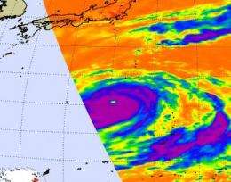
NASA's Aqua satellite again flew over Super Typhoon Choi-Wan late last night and captured visible and infrared imagery of the monster typhoon. Aqua's Atmospheric Infrared Sounder (AIRS) instrument and Moderate Imaging Spectroradiometer (MODIS) captured two different views of Choi-Wan's clouds.
AIRS showed Choi-Wan's cold high thunderstorm cloud temperatures were colder than minus 63 Fahrenheit indicating a very strong tropical cyclone. Also on Aqua, NASA's Moderate Imaging Spectroradiometer (MODIS) instrument captured a stunning look at Super Typhoon Choi-Wan's clouds with a clear eye.
At 11 a.m. EDT on September 17, Super Typhoon Choi-Wan had maximum sustained winds near 149 mph (130 knots), bringing the storm back down to Category 4 typhoon status. The center of Choi-Wan was located about 205 miles south-southwest of the island of Iwo To, near 22.0 north and 139.7 east, and was moving northwest at 9 mph. It continues to generate extremely high waves, up to 42 feet high.

Choi-Wan has weakened a little but the U.S. Navy's Joint Typhoon Warning Center (JTWC) noted that the storm remains a "fully developed cyclone with a very distinct symmetrical eye." That eye is clearly visible in the imagery from NASA's Aqua satellite today. The JWTC also noted that "Animated water vapor satellite imagery shows some erosion of deep convection to the northwest quadrant of the system. However, environmental analysis indicates the system remains in a corridor of low vertical wind shear and warm sea surface temperatures."
Choi-Wan is moving northwestward along the western edge of a sub-tropical ridge of high pressure, which has a clockwise circulation. If you think of a clock, Choi-Wan would be positioned near 7 or 8 o'clock. It will continue moving further in a northerly direction before heading in an easterly direction (think of it approaching 10 and 11 o'clock heading towards noon).
Choi-Wan is expected to start weakening on Friday, September 18 and will transition to an extra-tropical storm thereafter.
Source: NASA/Goddard Space Flight Center


