NASA eyes Category 4 Hurricane Felicia and a stubborn Enrique

Felicia is the storm that rules the Eastern Pacific Ocean this week, but Enrique refuses to give up. Felicia is a major hurricane with sustained winds near 140 mph, and Enrique is still hanging onto tropical storm status with 50 mph sustained winds. Both cyclones are close to each other and NASA satellites captured them together.
On August 6 at 5 a.m. EDT, powerful Felicia is still a Category Four hurricane on the Saffir-Simpson hurricane scale. She's far out to sea, about 1,480 miles west-southwest of the southern tip of Baja California near 15.5 north and 131.2 west. She's moving west-northwest near 10 mph, and is expected to speed up and start to weaken in the next couple of days because of colder waters in her path. Felicia's minimum central pressure is 937 millibars.
Boys can be stubborn, and Enrique is proving that, even though he's a tropical storm with a boy's name. Despite Enrique's close proximity to Felicia, he's maintaining sustained winds near 50 mph. At 5 a.m. EDT, Enrique's center was 345 miles behind Felicia's, near 20.7 north and 125.9 west. He's speeding northwest near 17 mph into cooler waters which is going to weaken him over the next day or two. Enrique's minimum central pressure is 1,000 millibars, much higher than Felicia's indicating a much weaker storm. The higher the atmospheric pressure the weaker the tropical cyclone.

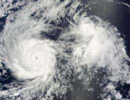
NASA's Terra satellite flew over Felicia and Enrique and using the Moderate Imaging Spectroradiometer (MODIS) instrument captured them side-by-side on August 5 at 3 p.m. EDT. The satellite image clearly showed an eye in powerful Hurricane Felicia, while Tropical Storm Enrique's eye was not clear.
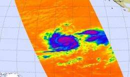
Terra wasn't the only satellite to capture Felicia and Enrique battling it out for territory in the Eastern Pacific Ocean. NASA's Aqua satellite also flew overhead and its Atmospheric Infrared Sounder (AIRS) instrument captured the frigid cloud temperatures in both storms. Felicia's clouds are colder and higher than Enrique's clouds, because stronger hurricanes have higher (and more powerful) thunderstorms.
Using AIRS and other infrared imagery to determine cloud temperature, the National Hurricane Center noted in their discussion on Aug. 6, that Felicia's eye has been warming and has become more well-defined over the past few hours but at the same time the cold cloud tops around the eye have also been warming." That's an indication that Felicia will start waning in strength.
Source: NASA/Goddard Space Flight Center


