Double Trouble for the Big Island of Hawaii: Flossie and Quakes

On Tuesday, August 14, 2007, the Big Island of Hawaii will feel Hurricane Flossie's effects after experiencing an earthquake the night before.
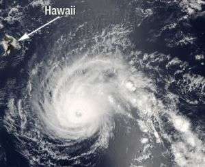
At 11:00 a.m. EDT, August 14, Hurricane Flossie was downgraded to a category two storm. It is on course to brush the Big Island of Hawaii today. Flossie has maximum sustained winds of 110 mph. At 5:00 a.m. EDT, Flossie was 260 miles south-southeast of Hilo, Hawaii moving west-northwest at 15 mph.
The Moderate Resolution Imaging Spectroradiometer (MODIS) on NASA's Aqua satellite captured this image of Hurricane Flossie on August 13 at 23:10 UTC (1:10 p.m. HST), as it swirled in the Pacific Ocean, approaching Hawaii.
According to local television station meteorologists at KHNL-TV, Channel 8, Hurricane Flossie's eye was starting to cloud over, indicating a sign of weakening. However, when a storm fills over, they stretch out over a larger area. Forecasters at KHNL-TV are calling for rainfall from 5 to 10 inches and very large surf up to 20 feet.
The earthquake which registered 5.3 on the Richter scale and hit at 7:38 p.m. HST on Monday the 13th, was centered 25 miles south of Hilo, Hawaii. That area is mainly rural with about 150,000 people, many of which live on the west or northeast side of the big island.
Source: NASA


