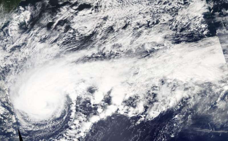
NASA satellite data shows Humberto's structure change

NASA's Aqua Satellite provided data on Major Hurricane Humberto that revealed its structure was changing as it was moving through the North Atlantic Ocean and past Bermuda.On Sept. 18 at 12:30 p.m. EDT, the Moderate Imaging Spectroradiometer or MODIS instrument that flies aboard NASA's Aqua satellite provided visible data on Humberto and measured clouds heights and temperatures that indicated a shift in the storm.
The visible image revealed powerful thunderstorms circled the center and a large band stretched hundreds of miles east. Additional data showed the highest cloud tops, higher than 12,000 meters (7.65 miles) were located mostly south and southwest of the eye, although a small area circled the eye. Those were the most powerful storms within Humberto. Aqua research data also found that cloud top temperatures were as cold as or colder than 200 Kelvin (minus 99.6 degrees Fahrenheit/minus 73.1 degrees Celsius) around in those storms. NASA research has shown that cloud top temperatures that cold have the capability to generate heavy rainfall.
The cloud height and temperature data was provided by NASA's Worldview product at NASA's Goddard Space Flight Center, Greenbelt, Md. Hurricanes are the most powerful weather event on Earth. NASA's expertise in space and scientific exploration contributes to essential services provided to the American people by other federal agencies, such as hurricane weather forecasting.
Hours later, NOAA's National Hurricane Center or NHC noted at 5 p.m. EDT, "Humberto is taking on more of a hybrid-extratropical structure based on most of the rain shield having been displaced to the left or poleward side of the circulation now as seen in Bermuda weather radar data, and also in conventional and passive microwave satellite imagery."
On Sept. 19 at 5 a.m. EDT, NHC indicated that Humberto's extratropical transition continued and that large-scale models, as well as the Florida State University Cyclone Phase Evolution forecast, indicate that the process will be completed in less than 36 hours.
At 11 a.m. EDT (1500 UTC) on Sept. 19, the center of Hurricane Humberto was located near latitude 35.2 degrees north and longitude 62.2 degrees west. Humberto was about 250 miles (400 km) northeast of Bermuda. Humberto is moving toward the northeast near 22 mph (35 kph). This general motion is expected to continue today, followed by a north-northeastward motion at a slower forward speed Thursday night and Friday. On the forecast track, the center of Humberto will continue to move away from Bermuda.
Maximum sustained winds are near 125 mph (205 kph) with higher gusts. Humberto is a category 3 hurricane on the Saffir-Simpson Hurricane Wind Scale. Hurricane-force winds extend outward up to 90 miles (150 km) from the center and tropical-storm-force winds extend outward up to 405 miles (650 km). The estimated minimum central pressure is 952 millibars.
On Sept. 19, Humberto was stirring up the seas and creating hazardous conditions.
Large swells and dangerous surf generated by Humberto will continue along the coast of Bermuda through today, and these could continue to cause coastal flooding. Swells will continue to affect the northwestern Bahamas and the southeastern coast of the United States from east-central Florida to North Carolina during the next couple of days.
The hurricane should start to weaken today, and it is expected to become a post-tropical cyclone by Friday.
More information: For updated forecasts, visit: http://www.nhc.noaa.gov
Provided by NASA's Goddard Space Flight Center


