NASA sees Chaba becoming extra-tropical

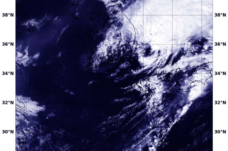
Tropical Storm Chaba moved into the Sea of Japan as NASA's Aqua satellite passed overhead and captured a visible picture of the storm as it was becoming extra-tropical and affected by wind shear.
Chaba's center moved between Japan's Kyushu Island and South Korea and into the Sea of Japan early on Oct. 5.
On Oct. 5 at 12:40 a.m. EDT (0440 UTC), the Moderate Resolution Imaging Spectroradiometer or MODIS instrument aboard NASA's Aqua satellite captured a visible image of Chaba after it entered the southern part of the Sea of Japan and encountered strong vertical wind shear. The visible image showed bulk of convection and clouds being pushed to the northeast of a very broad and elongated low level center.
On Oct. 5 at 4 a.m. EDT (0900 UTC) Chaba had maximum sustained winds near 57 mph (50 knots/92 kph) and was moving to the northeast at 39 mph (34 knots/63 kph). It was located near 37.0 degrees north latitude and 133.6 degrees east longitude. That's about 121 nautical miles (139 miles/224 km) north-northwest of Iwakuni, Yamaguchi, Japan. Yamaguchi is a prefecture in Japan's Chugoku region, on the southwest side of Honshu Island.
At that time, the U.S. Marine Corps Air Station at Iwakuni (MCAS Iwakuni) reported that Chaba had moved past (north) of the air station. However, the MCAS remained in "Tropical Cyclone Conditions of Readiness Storm Watch." That means "although destructive winds have subsided or currently no longer forecast, there is still a possibility of danger due to the proximity of the storm and due to the unforecasted changes in storm track and/or strength."
The Joint Typhoon Warning Center issued their final warning on the system and noted that animated multispectral satellite imagery showed that the low-level circulation center was exposed to outside winds and there were no longer any bands of thunderstorms circling the center. As a result of the wind shear, the storm appeared to resemble a frontal system more than a tropical cyclone.
Chaba was turning extra-tropical as it continued to race in a northeasterly direction through the Sea of Japan.
Provided by NASA's Goddard Space Flight Center


