NASA Spots "Hot Towers" in Intensifying Tropical Storm Frank

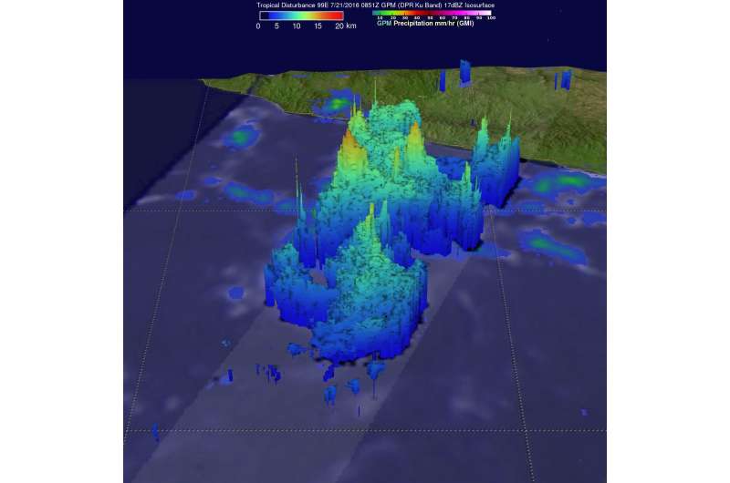
As tropical storm Frank was forming in the Eastern Pacific Ocean, NASA analyzed rainfall and cloud heights and found "hot towers" that indicated intensification was likely.
After the Global Precipitation Measurement mission or GPM core satellite passed over System 99E, it quickly strengthened into Tropical Depression 07E and then a tropical storm. The GPM core observatory satellite flew directly above the increasingly organized stormy area on July 21, 2016 at 0851Z (4:51 a.m. EDT). GPM found some powerful thunderstorms contained intense showers. Rain was measured by GPM's Dual-Frequency Precipitation Radar (DPR) instrument falling at a rate of over 184 mm (7.2 inches) per hour in a few of these convective storms.
GPM data also provided a 3-D look at the storms. GPM's radar (DPR Ku Band) slicing through these storms found that some tall thunderstorms were reaching heights of over 16 km (9.9 miles). GPM is a joint mission between NASA and the Japanese space agency JAXA.
A "hot tower" is a tall cumulonimbus cloud that reaches at least to the top of the troposphere, the lowest layer of the atmosphere. It extends approximately 9 miles/14.5 km high in the tropics. These towers are called "hot" because they rise to such altitude due to the large amount of latent heat. Water vapor releases this latent heat as it condenses into liquid. Those towering thunderstorms have the potential for heavy rain. NASA research shows that a tropical cyclone with a hot tower in its eyewall was twice as likely to intensify within six or more hours, than a cyclone that lacked a hot tower.
The National Hurricane Center (NHC) said at 5 a.m. EDT (0900 UTC), the center of Tropical Storm Frank was located near 16.7 latitude 16.7 North, longitude 106.3 West. That's about 205 miles (330 km) southwest of Manzanillo, Mexico. The estimated minimum central pressure was 1000 millibars.
Frank was moving toward the northwest near 12 mph (19 kph) and the NHC forecast a turn to the west-northwest with a decrease in forward speed during the next couple of days. On the forecast track, Frank is expected to move away from the southwest coast of Mexico and pass well south of the Baja California peninsula over the weekend.
Maximum sustained winds are near 50 mph (85 kph) with higher gusts. NHC said some strengthening is forecast during the next 48 hours, and Frank could become a hurricane during the weekend.
Provided by NASA's Goddard Space Flight Center


