NASA sees birth of Tropical Cyclone 20P, threatens American Samoa

As Tropical Cyclone 20P formed in the Southern Pacific Ocean NASA's Aqua satellite analyzed storm cloud top temperatures while the RapidScat instrument looked at surface winds. The National Weather Service in Pago Pago expects the tropical storm to affect American Samoa by the weekend.
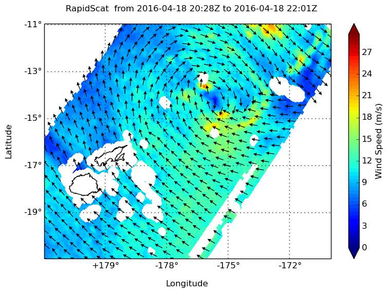
Before it became a tropical storm today, April 20, NASA's RapidScat instrument spied tropical-storm-force winds on the southern side of the developing tropical low pressure area on April 18. RapidScat saw strongest sustained surface winds south of the center of circulation near 21 meters per second (46.9 mph/75.6 kph).
RapidScat is a scatterometer instrument that flies aboard the International Space Station. It measures surface wind speeds and direction over open waters of oceans. Images from RapidScat data are made into images at NASA's Jet Propulsion Laboratory in Pasadena, California where the mission is managed.
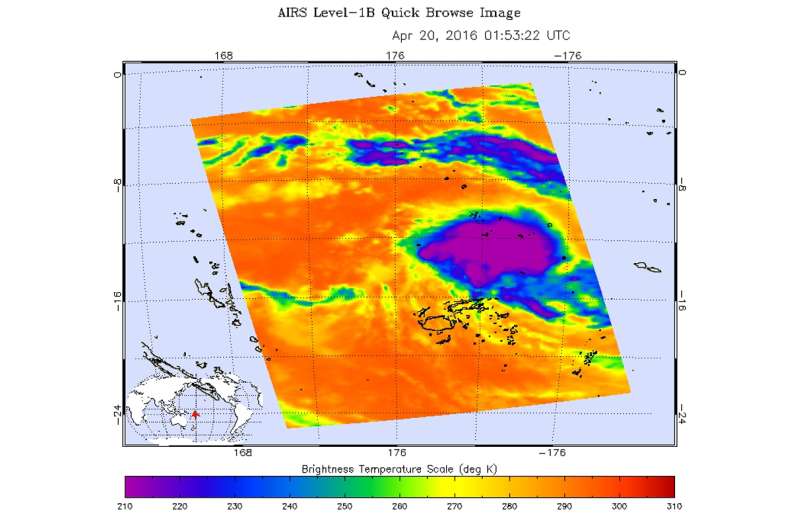
On April 20 at 01:53 UTC (April 19 at 9:53 p.m. EDT) infrared temperature data from the Atmospheric Infrared Sounder instrument that flies aboard NASA's Aqua satellite looked at the tropical low pressure area. The developing Tropical depression, located northeast of Fiji showed cold cloud top temperatures near minus 63 degrees Fahrenheit (minus 52 Celsius) indicating some strong storms.
At 0900 UTC (5 a.m. EDT), Tropical cyclone 20P had maximum sustained winds near 35 knots (40 mph/62 kph) making it a tropical storm. It was centered near 12.9 degrees south latitude and 178.8 degrees west longitude, about 352 nautical miles (405.3 miles/ 652.3 km) west of Avata, Samoa. 20P was moving to the west-northwest at 6 knots (6.9 mph/11.1 kph).

The National Weather Service in Pago Pago issued a high surf advisory on April 20 that includes warnings for rip currents. NWS noted "An active surface trough will continue to linger over the Samoan islands through the week. An intensifying tropical cyclone will turn and move over the Samoan islands by at least Saturday. Hazardous seas will continue to build through the weekend...reaching extremely dangerous heights by Friday night.
A flash flood watch is in effect for all islands of American Samoa through Saturday, April 23. NWS noted that "an active trough will remain nearly stationary over the Samoan islands through the week. This trough will continue to increase the potential for flash flooding across the territory...especially since grounds have been saturated."
The Joint Typhoon Warning Center forecast calls for 20P to curve to the east and intensify to 60 knots (69 mph/111 kph) before weakening south of Pago Pago.
Provided by NASA's Goddard Space Flight Center


