NASA measures US south heavy rainfall from space

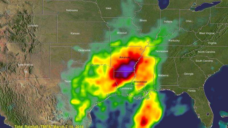
Extremely heavy rain fell over the southern United States during the past week and data from the Global Precipitation Measurement (GPM) mission core satellite and others in the GPM constellation provided a look at areas with heaviest rainfall. The data showed the largest amounts of rain fell from north central Louisiana to southern Arkansas.
A slow moving area of low pressure pumped moisture from the Gulf of Mexico causing torrential rain that resulted in widespread flooding in states from Texas to Tennessee over the last week. Over 24 inches of rain was reported in Monroe, Louisiana. Over 4,958 homes in Louisiana were reportedly damaged by the flooding. Strong winds accompanying intense thunderstorms also toppled trees in Mississippi and Louisiana.
At NASA's Goddard Space Flight Center in Greenbelt, Maryland, a merged satellite rainfall analysis (TMPA) using data collected from March 7 to 14, 2016 was created and made into an image and 3-D animation. The TMPA product uses climatology to calibrate multi-satellite precipitation data. The image showed that the heaviest rainfall stretched from northern Louisiana into south central Arkansas.
As of March 13, 2016 the National Weather Service (NWS) in Shreveport, Louisiana reported 12.12 inches of rain had fallen since March 1, 2016. That's 10.33 inches greater than average. North in El Dorado, Arkansas the NWS recorded 8.59 of rain through March 13, 2016 which is 6.48 inches over average.
On the same day, Louisiana Governor John Bel Edwards announced that the federal government declared a major disaster for the state. The initial federal declaration is for Bossier, Claiborne, Grant, Morehouse, Ouachita, Richland, and Webster Parishes. Additional parish declarations may be made after further assessments are done. For updated information visit: http://gov.louisiana.gov
On Monday, March 14, 2016, NWS Shreveport continued the flood warning for the Bayou D`Arbonne at Lake D`Arbonne at Farmerville, Louisiana until late Wednesday night...or until the warning is cancelled. Farmerville is located in the northeastern corner of the state where the IMERG product showed the heaviest rainfall accumulations. At 8:45 a.m. CDT NWS said the pool stage was 85.3 feet and moderate flooding was occurring and moderate flooding is forecast. The flood pool stage is 83 feet. NWS expects the lake will continue to fall to below flood pool stage by Wednesday morning, March 16.
NOAA's National Weather Service Weather Prediction Center in College Park, Maryland stated in the morning discussion on Monday, March 14, 2016: After days of heavy rainfall and flooding across Texas and the lower Mississippi Valley, the pattern will be changing as the deep moisture feed from the Gulf of Mexico weakens. River levels will remain quite high across this region as all of the rain water slowly drains away.
Provided by NASA's Goddard Space Flight Center


