February was warmest month in satellite record
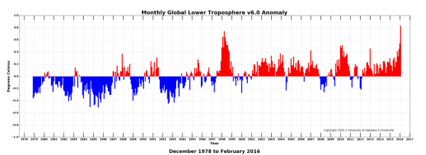
By a statistically significant amount, February 2016 was the warmest month in the satellite temperature record, according to Dr. John Christy, director of the Earth System Science Center at The University of Alabama in Huntsville. Interestingly, however, that record might have as much to do with an extraordinarily warm month in the Arctic as it does with warming caused by the El Niño Pacific Ocean warming event.
Globally, the average temperature anomaly in February (+0.83 C) was warmer than the previous record set in April 1998 (+0.74 C) during the so-called "El Niño of the century."
In the Northern Hemisphere, the February anomaly (+1.17 C) was a full 0.32 C (0.58 F) warmer than the previous NH record (+0.85 C) set in April 1998. Temperatures in the tropics and the Southern Hemisphere were not at record levels in February.
While the Arctic temperature anomaly is large, big temperature swings in the Arctic region aren't unusual, especially during the winter months. Those swings are also normally somewhat transient, so the extra heat represented in February could dissipate over the next few weeks. If that happens, it doesn't appear the heat from the El Niño by itself will be enough to continue pushing temperatures to new records later in the year, in which case this February anomaly might stand out as a singular spike in the dataset rather than part of an ongoing trend.
- Global climate trend since Nov. 16, 1978: +0.12 C per decade
- February temperatures (preliminary)
- Global composite temp.: +0.83 C (about 1.50 degrees Fahrenheit) above 30-year average for February.
- Northern Hemisphere: +1.17 C (about 2.11 degrees Fahrenheit) above 30-year average for February.
- Southern Hemisphere: +0.50 C (about 0.90 degrees Fahrenheit) above 30-year average for February.
- Tropics: +0.99 C (about 1.78 degrees Fahrenheit) above 30-year average for February.
- January temperatures (revised):
- Global Composite: +0.54 C above 30-year average
- Northern Hemisphere: +0.69 C above 30-year average
- Southern Hemisphere: +0.39 C above 30-year average
- Tropics: +0.85 C above 30-year average
- (All temperature anomalies are based on a 30-year average (1981-2010) for the month reported.)
The warmest months in the satellite temperature record are:
Warmest Months, Global
Amount warmer than seasonal norms
- Feb. 2016 0.83 C
- Apr. 1998 0.74 C
- Feb. 1998 0.65 C
- May 1998 0.64 C
- June 1998 0.57 C
- Jan. 2016 0.54 C
- Aug. 1998 0.52 C
- Mar. 2010 0.50 C
- Jan. 1998 0.48 C
- Mar. 1998 0.47 C
- Feb. 2010 0.47 C
Warmest NH Months
- Feb. 2016 1.17 C
- Apr. 1998 0.85 C
- Jan. 2016 0.70 C
- Feb. 1998 0.66 C
- July 1998 0.65 C
- Oct. 2015 0.63 C
- June 1998 0.60 C
- Jan. 2010 0.60 C
- May 2010 0.60 C
- Mar. 2010 0.59 C
Warmest Februaries, Global
- 2016 0.83 C
- 1998 0.65 C
- 2010 0.47 C
- 2002 0.30 C
- 2003 0.25 C
- 2004 0.25 C
- 2007 0.19 C
- 2015 0.19 C
- 2005 0.18 C
- 2006 0.17 C
- 1999 0.17 C
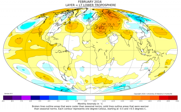
Compared to seasonal norms, the warmest average temperature anomaly on Earth in February was over north central Russia, near the small town of Beloyarsky. February temperatures there averaged 5.20 C (about 9.36 degrees F) warmer than seasonal norms. Compared to seasonal norms, the coolest average temperature on Earth in February was over the Sea of Okhotsk, between the Russian mainland and the Kamchatka Peninsula, where the average February 2016 temperature was 3.25 C (about 5.85 degrees F) cooler than normal for February.
As part of an ongoing joint project between UAHuntsville, NOAA and NASA, Christy and Dr. Roy Spencer, an ESSC principal scientist, use data gathered by advanced microwave sounding units on NOAA and NASA satellites to get accurate temperature readings for almost all regions of the Earth. This includes remote desert, ocean and rain forest areas where reliable climate data are not otherwise available.
The satellite-based instruments measure the temperature of the atmosphere from the surface up to an altitude of about eight kilometers above sea level. Once the monthly temperature data are collected and processed, they are placed in a "public" computer file for immediate access by atmospheric scientists in the U.S. and abroad.
More information: The complete version 6 beta lower troposphere dataset is available here: vortex.nsstc.uah.edu/data/msu/ … ncdc_lt_6.0beta5.txt
Archived color maps of local temperature anomalies are available on-line at: nsstc.uah.edu/climate/
Provided by University of Alabama in Huntsville


