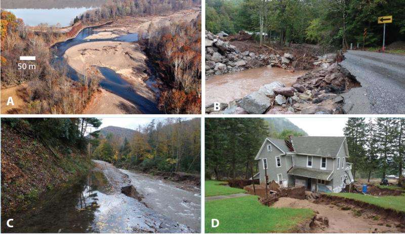
Geomorphic impact of the flooding caused by tropical storm Lee in September 2011

In their article for Geosphere, R. Craig Kochel and colleagues discuss the geomorphic impact of the flooding caused Tropical Storm Lee in September 2011 on several large watersheds of the Susquehanna River in the Appalachian Plateau region of north-central Pennsylvania. Unlike many Appalachian floods, the physical impacts to channels and floodplains were extensive.
Channel widening (in places >100%) and bank erosion were common, and huge volumes of gravel were transported during the flood. Flood flows resulted in a significant threshold, crossing where channel patterns shifted from single-channel to multi-thread along many reaches.
Kochel and colleagues suggest that part of the reason for such extensive changes from the flood were related to the land-use history of these watersheds. Watershed-scale deforestation occurred in these streams between 1850 and 1920, resulting in hillslope erosion and downstream floodplain sedimentation. In addition, the former multi-thread gravel-bed channel system was altered by the construction of berms, narrowing the active part of the streams to a single channel.
After the logging era, infrastructure (including homes, highways, and farms) was established on the floodplain that was protected by the berms. The 2011 flood breached these berms, aggraded channels with gravel bars to floodplain elevations, and resulted in numerous avulsions and chutes eroded through the insides of meander bends. These changes reconnected the modified single-channel system with its preexisting multi-thread channel system and resulted in extensive damage to highways, bridges, farms, homes, and other infrastructure in the region.
The increased coarse gravel load available to channels is causing rivers to adjust their morphology and return to multi-thread systems where flood flows occupy numerous channels across valley-wide floodplains. Understanding the trajectory of the geomorphic adjustment of streams in this region is critical to making wise management and land-use policy decisions. Watershed managers would find prudence in evaluating fluvial systems on a watershed scale that addresses adjustments in sediment load and discharge produced by natural changes as well as historical land-use practices.
More information: R. Craig Kochel et al. Geomorphic response to catastrophic flooding in north-central Pennsylvania from Tropical Storm Lee (September 2011): Intersection of fluvial disequilibrium and the legacy of logging, Geosphere (2015). DOI: 10.1130/GES01180.1
Journal information: GeoSphere
Provided by Geological Society of America


