NASA analyzes Tropical Storm In-fa's winds, rain

As Tropical Storm In-fa continued to affect Micronesia and the Marianas Islands, NASA's RapidScat instrument measured surface winds and the Global Precipitation Measurement mission or GPM core satellite measured areas of intense rainfall. In-fa became a typhoon early on Nov. 18 and weakened slightly to a tropical storm later in the day, maintaining tropical-storm force on Nov. 19.
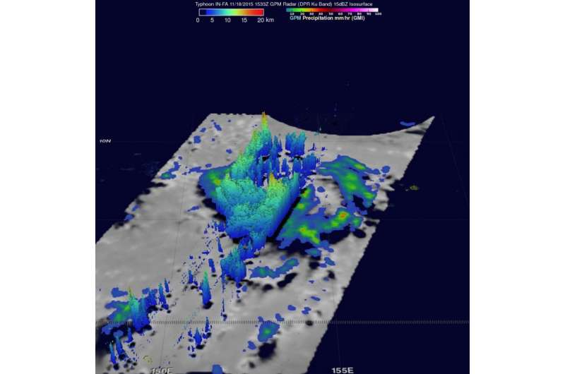
On Nov. 18 at 1533 UTC (10:33 a.m. EST) the GPM core observatory satellite flew directly over In-fa when it was a typhoon, far to the southeast of Guam. Favorable environmental conditions such as low vertical wind shear and warm sea surface temperatures helped typhoon In-fa intensify quickly from a tropical depression on November 17 to a typhoon on November 18, 2015.
At NASA's Goddard Space Flight Center in Greenbelt, Maryland, rainfall data from GPM's Microwave Imager (GMI) and Dual-Frequency Precipitation Radar (DPR) instruments were used to analyze the rainfall around typhoon In-fa. GPM's DPR found that rain was falling at a rate over 74 mm (2.9 inches) per hour in powerful convective thunderstorms to the south of the typhoon's center.
The data was also used to create a 3-D image showing a cross-section of radar reflectivity values that GPM's Radar (Ku Band) cut through the typhoon. Storm top heights reached heights of up to 16.7 km (10.4 miles) in convective storms within a feeder band to the west of In-fa's eye.

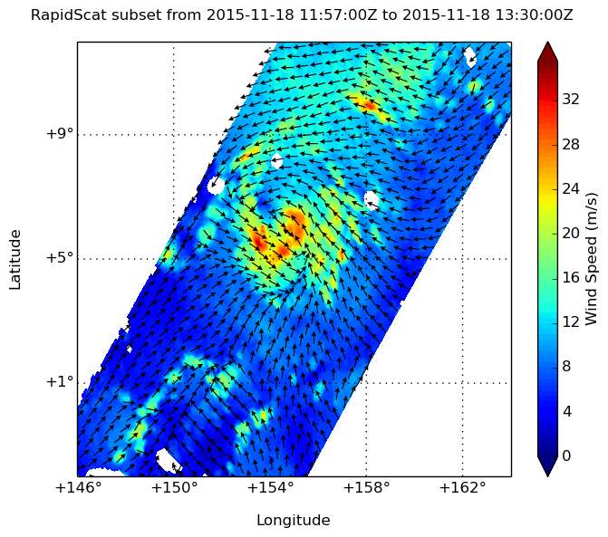
On Nov. 18 at about 1 p.m. EST, the International Space Station passed over In-fa when it was still hanging onto typhoon status. The RapidScat instrument that flies aboard measured strongest sustained winds wrapped from east to south to west near 33 meters per second (74 mph/119 kph). On Nov. 19, tropical storm force winds extended outward up to 85 miles east of the center and up to 75 miles west of center.
On Nov. 19 at 1200 UTC (7 a.m. EST/10 p.m. Guam CHST local time), a High Surf Advisory was in effect for Micronesia, and a High Surf Warning or Advisory was in effect for the Marianas. A typhoon warning remains in effect for Ulul in Chuuk state. A tropical storm watch remains in effect for Guam.
At that time, the center of tropical storm in-fa was located by Himawari satellite and microwave data near latitude 9.1 degrees north and longitude 150.3 degrees east, moving west-northwest at 18 mph. This general motion is expected to continue through Friday, Nov. 20. Maximum sustained winds are estimated at 70 mph making it close to typhoon intensity. In-fa is expected to continue to intensify over the next few days.
NOAA's National Weather Service Office in Tiyan, Guam noted that "In-fa remains a strong tropical storm and is moving quickly away from Fananu in a direction that will place it just south of the Guam coastal waters early Saturday morning. Maximum sustained winds are 65 mph. In-fa is expected to intensify over the next 24
Hours and could become a typhoon again overnight."
Residents of the Marianas should closely monitor the progress of Typhoon In-fa by keeping up with the latest statements and advisories issued by the national weather service at: http://www.prh.noaa.gov/guam/.
Provided by NASA's Goddard Space Flight Center


