NASA sees a speedy Extra-Tropical Storm Choi-Wan

NASA's Aqua satellite passed over Tropical Storm Choi-wan as it moved over cooler waters and was becoming an extra-tropical storm.
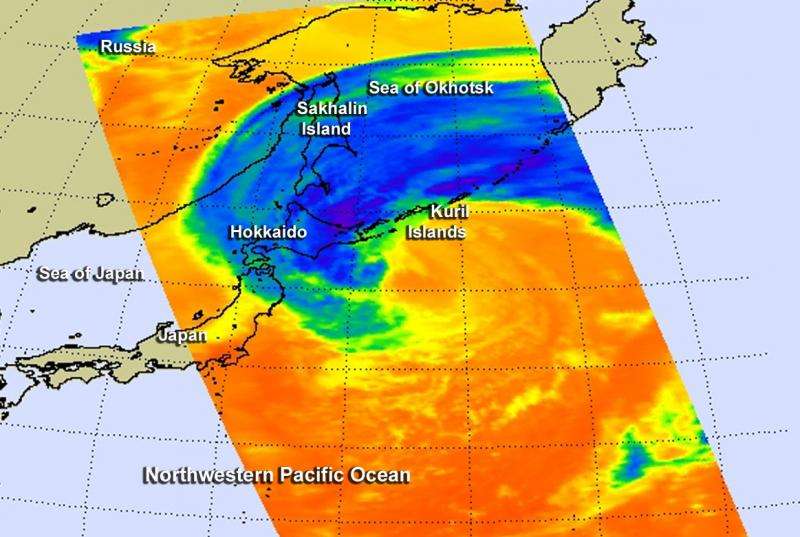
The Atmospheric Infrared Sounder or AIRS instrument aboard NASA's Aqua satellite looked at Choi-wan on Oct. 8 at 3:11 UTC (Oct. 7 11:11 p.m. EDT). The bulk of cold clouds were northwest of the center just east of Hokkaido, Japan's second largest and northernmost island of Japan's 47 prefectures. Choi-wan's clouds also extended over the Kuril Islands and over Russia's Sakhalin Island, part of Sakhalin Oblast. Choi-wan's cold clouds also extended over the northernmost part of the Sea of Japan and Sea of Okhotsk.
On October 7 at 2100 UTC (5 p.m. EDT), Tropical Storm Choi-wan was becoming extra-tropical as it moved through cooler waters near the Kuril islands in the Northwestern Pacific Ocean. That's when the Joint Typhoon Warning Center issued the final warning on the storm. At that time maximum sustained winds were near 60 knots (69 mph/111.1 kph). It was centered about 460 nautical miles east-southeast of Misawa, Japan, near 27.6 North latitude and 150.4 East longitude. Choi-wan was moving to the north at a speedy 38 knots (44.8 mph/72.2 kph).
A cyclone has lost its "tropical" characteristics. The National Hurricane Center defines "extra-tropical" as a transition that implies both poleward displacement (meaning it moves toward the north or south pole) of the cyclone and the conversion of the cyclone's primary energy source from the release of latent heat of condensation to baroclinic (the temperature contrast between warm and cold air masses) processes. It is important to note that cyclones can become extratropical and still retain winds of hurricane or tropical storm force.
The Japan Meteorological Agency (JMA) noted on October 8 at 0345 UTC (Oct. 7 at 11:45 p.m. EDT), Choi-Wan was located near 41.0 North latitude and 148.0 East longitude, and moving closer to the Kuril Islands. It was moving to the north at 18.9 knots (21.7 mph/35 kph) and had a minimum central pressure of 945 millibars. At 11:35 p.m. Japan local time storm warnings were in effect for the Kuril Islands.
For updated warnings in Japan, visit the JMA webpage: http://www.jma.go.jp/en/seawarn/index.html.
Provided by NASA's Goddard Space Flight Center


