NASA analyzes record-breaking Hurricane Patricia

NASA satellites and instruments have been monitoring the record-breaking Hurricane Patricia as it rapidly intensified off the southwestern coast of Mexico on October 23. NASA-NOAA's Suomi NPP saw frigid cloud top temperatures, NOAA's GOES-West satellite provided imagery and animations that showed the extent of the storm, NASA's Terra satellite provided visible data, and the RapidScat instrument aboard the International Space Station measured its surface winds.
Suomi NPP Satellite Sees Frigid High Clouds
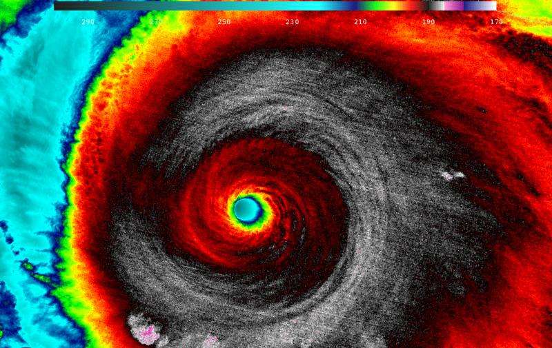
When NASA-NOAA's Suomi NPP satellite passed over Patricia on October 23 at 5:20 a.m. EDT the Visible Infrared Imaging Radiometer Suite or VIIRS instrument that flies aboard Suomi NPP looked at the storm in infrared light. "Cloud top temperatures of thunderstorms around the eyewall were between 180K (-135.7F/ -93.1C) and 190 Kelvin (-117.7F/ -83.1C)," said William Straka III of the University of Wisconsin, Madison. "Then, as you go into the eye itself, it gets warmer."
The higher the cloud tops, the colder they are as temperatures get colder with altitude in the troposphere. Storms with cloud top temperatures that cold have the capability of generating heavy rainfall.
GOES Satellite Animation Shows Rapid Intensification
On October 22, Patricia was a Category one hurricane. By 8 a.m. EDT on October 23, 2015, the National Hurricane Center reported Patricia became the strongest eastern north pacific hurricane on record with sustained winds near 200 mph.
An animation of images captured from October 20 to 23 from NOAA's GOES-West satellite showed Hurricane Patricia intensify within 24 hours and develop a clear eye near the coast of western Mexico. The animation was created at NASA/NOAA GOES Project at NASA's Goddard Space Flight Center, Greenbelt, Maryland.
NASA's Terra Satellite Sees Northeastern Quadrant Already Over Mexico

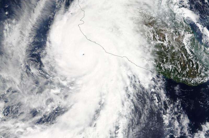
On Oct. 23 at 17:30 UTC (1:30 p.m. EDT) the Moderate Resolution Imaging Spectroradiometer instrument aboard NASA's Terra satellite saw the eastern quadrant of Hurricane Patricia over Mexico and the storm's pinhole eye.
Watches and Warnings on October 23, 2015
A Hurricane Warning is in effect from San Blas to Punta San Telmo and a Hurricane Watch is in effect from east of Punta San Telmo to Lazaro Cardenas. A Tropical Storm Warning is in effect from east of Punta San Telmo to Lazaro Cardenas and north of San Blas to El Roblito.
Two Records Broken
The National Hurricane Center reported that Patricia is the strongest hurricane on record in the National Hurricane Center's area of responsibility (AOR) which includes the Atlantic and the eastern North Pacific basins. The minimum central pressure estimated from the aircraft data, 880 millibars, is the lowest ever for our AOR. The National Hurricane Center noted "It seems incredible that even more strengthening could occur before landfall later today [October 23]. The official forecast shows only a little more strengthening before landfall."
Status of Hurricane Patricia on October 23 at 2 p.m. EDT
At 2 p.m. EDT (1800 UTC) on October 23, the center of Hurricane Patricia was located near latitude 18.2 North, longitude 105.3 West. Patricia was moving toward the north near 12 mph (19 kph). On the forecast track, the center of Patricia should cross the coast in the hurricane warning area during the next several hours. After landfall, the center of Patricia is expected to move quickly north-northeastward across western and northern Mexico.
Reports from a NOAA Hurricane Hunter aircraft indicate that maximum sustained winds remain near 200 mph (325 kph) with higher gusts. Patricia is a category 5 hurricane on the Saffir-Simpson Hurricane
Wind Scale. Patricia is expected to remain an extremely dangerous category 5 hurricane through landfall. After landfall, Patricia is forecast to rapidly weaken over the mountains of Mexico. Hurricane force winds extend outward up to 35 miles (55 km) from the center and tropical storm force winds extend outward up to 175 miles (280 km). The minimum central pressure estimated from the NOAA aircraft data was 879 millibars.
Landfall Expected at Night, October 23/Early October 24 as a Category 5
Forecaster Beven of the National Hurricane Center stated in a discussion that Patricia is expected to make landfall as a Category 5 hurricane in southwestern Mexico in less than 12 hours. After landfall, a combination of the mountainous terrain of Mexico and increasing shear should cause the cyclone to rapidly weaken, with the system likely to dissipate completely after 36 hours.
Despite dissipation, the National Hurricane Center said that development of another low pressure area is expected to draw significant amounts of moisture from Patricia's remnants, and could result in locally heavy rainfall over portions of the northwestern Gulf of Mexico coastal area within the next few days.
For updated forecasts, watches and warnings, visit: http://www.nhc.noaa.gov.
Provided by NASA's Goddard Space Flight Center


