NASA's GPM measured Typhoon Champi's heavy rainfall

Typhoon Champi has been generating heavy rainfall since Oct. 16, 2015, when NASA's Global Precipitation Measurement, or GPM, mission analyzed the storm. The storm intensified from a tropical storm to a typhoon after GPM passed overhead. GPM is a joint mission between NASA and JAXA.
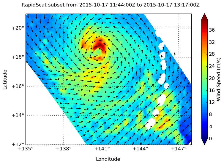
The RapidScat instrument aboard the International Space Station also showed what side of the storm had the strongest winds.
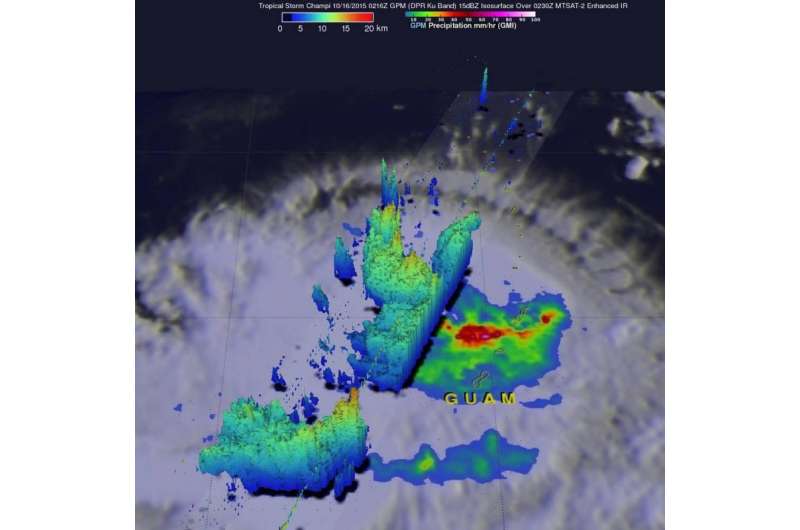
On Oct. 16, 2015, at 0216 UTC the GPM core observatory satellite passed above Champi when it was a tropical storm drenching the Northern Marianas Islands. GPM's Dual-Frequency Precipitation Radar (DPR) measured rain within Champi falling at a rate of over 114.8 mm (4.5 inches) per hour in a band of intense showers.
GPM's radar sliced through Champi's western side and made 3-D measurements of storm top heights. Radar reflectivity values found to be greater than 15 dBZ are shown in a simulated perspective 3-D view. The lowest heights are shaded blue and the tallest 3-D 15dBZ surfaces are colored red. GPM measured storm tops (orange) that were reaching altitudes above 16.5 km (10.2 miles) within a strong feeder band southwest of Guam.
The Joint Typhoon Warning Center (JTWC) determined that Tropical Storm Champi had reached typhoon status with winds of 65 knots (74.8 mph) about 10 hours after GPM collected data with that pass.
The next day, the RapidScat instrument saw Champi's strongest winds in Champi's northern quadrant on Oct. 17 at 1300 UTC (9 a.m. EDT). Strongest winds were near 40 meters per second (89.4 mph/144 kph). Typhoon force winds also circled the center of Champi's eye, but were not as strong as those in the northern quadrant.

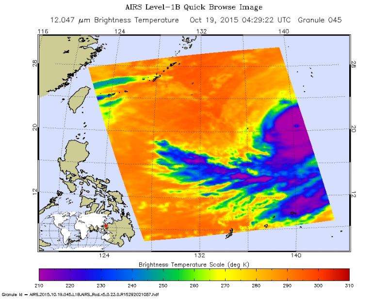
On Oct. 19 at 12:29 a.m. EDT, the Atmospheric Infrared Sounder, or AIRS, instrument that flies aboard NASA's Aqua satellite captured temperature data on the typhoon's clouds. Cloud top temperatures exceeded the threshold of -63F/-53C, which indicates powerful storms stretching high in the troposphere with the capability to continue dropping the heavy rainfall GPM saw three days before. The strongest thunderstorms were south of the center, while north of the center, sinking air was eroding developing storms. Infrared data also showed that Champi's eye was 24 nautical miles (27.6 miles/44.4 km) in diameter.
At 1500 UTC (11 a.m. EDT) on Oct. 19, Champi's maximum sustained winds were near 100 knots (115 mph/185 kph). Champi was centered near 21.1 North latitude and 140.1 East longitude, about 236 nautical miles (271 miles/437 km) south-southwest of Iwo To island, Japan. Champi has tracked north-northwestward at just 2 knots (2.3 mph/3.7 kph) and is generating very rough seas at 10.9 meters (36 feet).
For the latest updates on Iwo To warnings and watches from the Japan Meteorological Agency, visit: http://www.jma.go.jp/en/typh/.

Joint Typhoon Warning Center noted on Oct. 19 that the total precipitable water (animation) loop shows dry air beginning to wrap into the western edge of the circulation, elongating the cloud system structure.
The JTWC forecast calls for Champi to continue a slow crawl north and make a very close approach Iwo To on Oct. 22, while turning to the northeast. Champi is forecast to weaken as it moves over cooler waters, and continues to be affected by dry air moving into the system.
Provided by NASA's Goddard Space Flight Center


