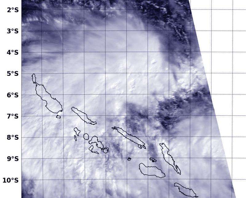
NASA sees new depression forms near Solomon Islands

The Southern Pacific Ocean Tropical Cyclone Season just got an extension with the birth of a new tropical depression near the Solomon Islands. NASA's Aqua satellite passed over the new depression and saw that it was already affecting some of the islands.
The Solomon Islands make up a nation that consists of hundreds of islands in the South Pacific.
The MODIS or Moderate Resolution Imaging Spectroradiometer instrument aboard NASA's Aqua satellite captured a visible image of Tropical Depression 25P as it was forming in the Southern Pacific, just north of the Solomon Islands on June 30, 2015 at 03:25 UTC (June 29 at 11:25 p.m. EDT). Clouds in the depression's western quadrant were covering many of the islands, and stretched over the Vella Gulf, Kula Gulf, New Georgia Sound, Blanche Channel, Indispensable Strait, Iron Bottom Sound and southwest into the Solomon Sea.
The South Pacific cyclone season is the time when most tropical cyclones form within the South Pacific Ocean to the east of 160° East Longitude. The 2014-2015 season officially runs from November 1, 2014 to April 30, 2015, however, tropical cyclones can form between July 1, 2014 and June 30, 2015. So, Tropical Depression 25P just squeezed in. Tropical Depression 25P (TD25P) also counts toward the season total.
On Tuesday, June 30, 2015, TD25P was born in the South Pacific Ocean, north of the Solomon Islands. By 1500 UTC (11 a.m. EDT), TD25P's maximum sustained winds were near 30 knots (35.5 mph/55.5 kph). TD25P was centered near 5.6 South latitude and 159.8 East longitude, about 1,068 nautical miles north-northwest of Noumea, New Caledonia. TD25P was moving to the south-southwest at 7 knots (8 mph/12.9 kph).
The Joint Typhoon Warning Center (JTWC), who manages bulletins for tropical cyclones in the Southern Pacific Ocean, noted that satellite imagery showed that TD25P is showing stronger central convection (rising air that forms thunderstorms that make up a tropical cyclone) with tightly-curved bands of thunderstorms wrapping into the low-level center (which is getting better organized).
TD25P is located in a favorable environment with low vertical wind shear (winds that can blow a tropical cyclone apart). The depression is expected to strengthen into a tropical storm before crossing Malaita and moving south over Guadalcanal. JTWC forecasters expect TD25P will move in a southerly direction after moving over Guadalcanal and emerge into the Coral Sea on July 3.
Provided by NASA's Goddard Space Flight Center


