TRMM sees large and more powerful Cyclone Pam, warnings posted

The Tropical Rainfall Measuring Mission or TRMM satellite saw powerful towering thunderstorms in Tropical Cyclone Pam, indicating the storm was strengthening as it moved through the Solomon Islands. Pam has now triggered warnings in the Solomon Islands, Vanuatu and New Zealand.
In the Solomon Islands, a tropical cyclone warning was in effect today, March 11, for Temotu, Malaita and Makira provinces. A tropical cyclone watch was in effect for Rennell and Bellona, Central, Isabel, Western, Guadalcanal and the Choiseul provinces.
In Vanuatu, a tropical cyclone warning is in effect for the provinces of Torba, Penama, Sanma and Malampa. In the next day to day and a half, the Shefa and Tafea provinces will feel the effects of Pam.
Additional warnings are also in effect in New Zealand as Pam continues to head south. Parts of the North Island are likely to be affected by severe weather on Monday, March 16. The areas cited under the warning are Gisborne and northern Hawkes Bay.
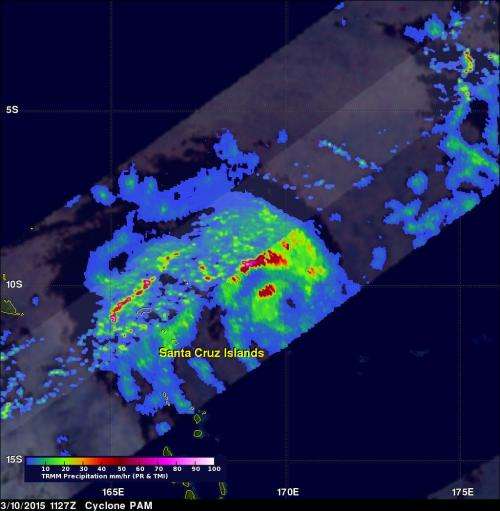
The TRMM satellite had a good look at Cyclone Pam on March 10, 2015 at 1127 UTC 7:27 a.m. EDT) when maximum sustained winds were estimated at 80 knots (92 mph). TRMM's Microwave Imager (TMI) showed that heavy rainfall from Pam covered a large area of the South Pacific Ocean near the Santa Cruz Islands. The eye of the intensifying tropical cyclone was shown passing to the east of the Santa Cruz Islands.
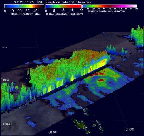
One of Pam's intense feeder (thunderstorm) bands northwest of the islands was dropping rain at a rate of over 158 mm (6.2 inches) per hour. TRMM's Precipitation Radar (PR) instrument covered the area to the northwest of Pam's eye and data was used to create a 3-D view of the storm that showed some cloud top heights there were reaching heights above 16 km (9.9 miles). TRMM is managed by both NASA and the Japan Aerospace Exploration Agency.

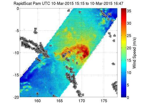
On Mar. 10, 2015, between 15:15 to 16:47 UTC, the International Space Station's RapidScat instrument showed Tropical Cyclone Pam's strongest maximum sustained winds were near 35 meters per second (78.9 mph/126 kph) north and east of the center of circulation.
On March 11 at 0900 UTC (5 a.m. EDT) Tropical Cyclone Pam's (known as 11F in Fiji) maximum sustained winds were near 105 knots (121 mph/194 kph). It was centered near 11.2 south latitude and 169.7 east longitude, about 653 nautical miles (751.5 miles/ 1,209 km) northwest of Suva, Fiji. Pam was moving to the south-southwest at 2 knots (2.3 mph/3.7 kph).
Pam continues moving south through the Solomon Islands, while intensifying. The Joint Typhoon Warning Center forecast takes Pam east of Vanuatu. The forecast then calls for Pam to become extra-tropical when it passes northeast of New Zealand.

Provided by NASA's Goddard Space Flight Center


