NASA eyes Tropical Cyclone Nathan's Australian comeback

NASA's Aqua satellite saw Tropical Storm Nathan preparing for its Australian "comeback" as the storm made a loop in the Coral Sea and is headed back to Queensland.
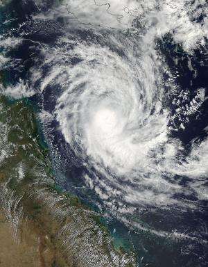
Two instruments aboard Aqua, MODIS and AIRS captured data on Nathan as it was tracking back toward Queensland. The Moderate Resolution Imaging Spectroradiometer or MODIS instrument captured a visible image of Nathan on March 17 at 03:35 UTC (March 16 at 11:35 p.m. EDT). Nathan appeared to have strong thunderstorms around the center with a band of thunderstorms wrapping into it from the south.
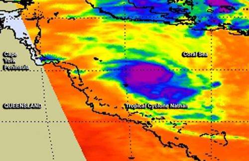
The Atmospheric Infrared Sounder or AIRS instrument gathered infrared data on Nathan. Infrared data shows temperatures, and the colder the cloud top temperatures, the higher the thunderstorms that make up the tropical cyclone. The cloud top temperatures around Nathan's center were near -63F/-52C, indicating strong storms with potential for heavy rainfall. The thunderstorms wrapping into the center from the south appeared to be a fragmented band.
At 0900 UTC (5 a.m. EDT), Tropical cyclone Nathan had maximum sustained winds near 45 knots (51.7 mph/83.3 kph). Nathan had moved south-southwest at 2 knots (2.3 mph/3.7 kph) and was centered near 14.6 south latitude and 149.5 east, about 254 nautical miles (292 miles/ 470 km) north-northeast of Cairns, Australia.
Forecasters at the Joint Typhoon Warning Center (JTWC) expect Nathan continue a slow crawl and slowly intensify to 75 knots, as it moves west. The Australian Bureau of Meteorology (ABM) forecast now calls for Nathan to make landfall in Queensland between Cooktown and Cairns around 10 a.m. local time on March 20.

ABM has not yet issued warnings, but posted a tropical cyclone watch from Cape Melville to Cardwell. ABM noted "gales may develop in the 24 to 48 hour period between Cape Melville and Cardwell, most likely late on Thursday afternoon or evening. Coastal residents between Cape Melville and Cardwell are specifically warned of the possibility of a dangerous storm tide as the cyclone crosses the coast." For updated forecasts from ABM, visit: http://www.bom.gov.au/.
Provided by NASA's Goddard Space Flight Center


