NASA measured nor'easter's powerful winds from space

When blizzard warnings were in effect in New England, NASA's ISS-RapidScat instrument provided forecasters with wind speed data on the nor'easter that had hurricane-force wind gusts.
"The nor'easter has been over a large enough region that RapidScat has had ascending and descending passes over parts of it every 24 hours," said Doug Tyler who creates RapidScat imagery at NASA's Jet Propulsion Laboratory in Pasadena, California.
The International Space Station-Rapid Scatterometer, or ISS-RapidScat was launched Sept. 21, 2014 to the International Space Station. From the unique vantage point of the space station, this space-based scatterometer instrument uses radar pulses reflected from the ocean's surface from different angles to calculate ocean surface wind speeds and directions.
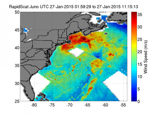
On Jan. 27 from 1:59 to 11:15 UTC (Jan. 26 at 8:59 p.m. EST to Jan. 27 at 6:15 a.m. EST), RapidScat saw the nor'easter's strongest winds from eastern Long Island, New York to southern Nova Scotia, Canada. During that period, sustained winds were between 30 meters per second (108 kph/67.1 mph) to 35 m/s (78.2 mph/126 kph). A category one hurricane on the Saffir-Simpson hurricane wind scale has maximum sustained winds from 74 to 95 mph (119 to 153 kph).
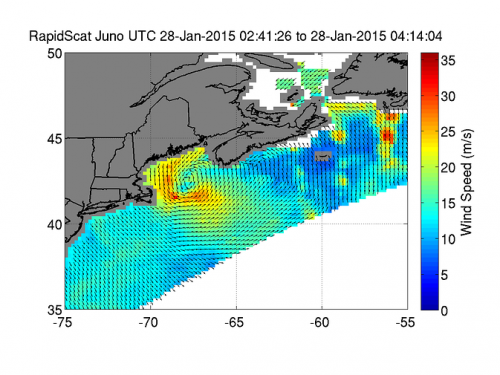
RapidScat obtained wind data on Jan. 28, 2015, from 2:41 to 4:14 UTC (9:41 p.m. and 11:14 p.m. EST on Jan. 27) as the nor'easter moved east and north. RapidScat data showed the center of the nor'easter was east of Massachusetts, with the strongest winds from northwest to southeast of the center. At the time, the strongest winds appeared just off-shore from eastern Cape Cod, sustained between 25 (90 kph/55.9 mph) and 30 meters (108 kph/67.1 mph) per second.
According to the National Weather Service in Taunton, Massachusetts, the January 27 climate summary for Boston indicated the highest sustained wind speed was 32 mph from the north, and the highest wind gust, also from the north, was 45 mph. Boston also set a record for snowfall on January 27 with a total of 22.1 inches.

Officially, the National Weather Service defines a blizzard as a storm which contains large amounts of snow OR blowing snow, with winds in excess of 35 mph and visibilities of less than one quarter mile for an extended period of time (at least 3 hours). When these conditions are expected, the National Weather Service will issue a "Blizzard Warning." When these conditions are not expected to occur simultaneously, but one or two of these conditions are expected, a "Winter Storm Warning" or "Heavy Snow Warning" may be issued.
NOAA's National Weather Service noted on January 28, 2015, "The powerful nor'easter that brought moderate to heavy snowfall and blizzard conditions to the Northeast on Monday will continue to affect the region on Tuesday, with heavy snow and blizzard conditions expected from eastern Long Island to Maine as the system slowly moves to the northeast."
Provided by NASA's Goddard Space Flight Center


