NASA satellite data shows Hagupit dropped almost 19 inches of rainfall

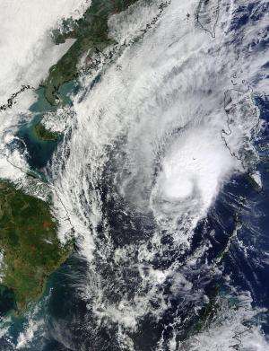
Typhoon Hagupit soaked the Philippines, and a NASA rainfall analysis indicated the storm dropped almost 19 inches in some areas. After Hagupit departed the Philippines as a tropical storm, NASA's Terra satellite passed over and captured a picture of the storm curled up like a cat waiting to pounce when it landfalls in Vietnam on Dec. 11.
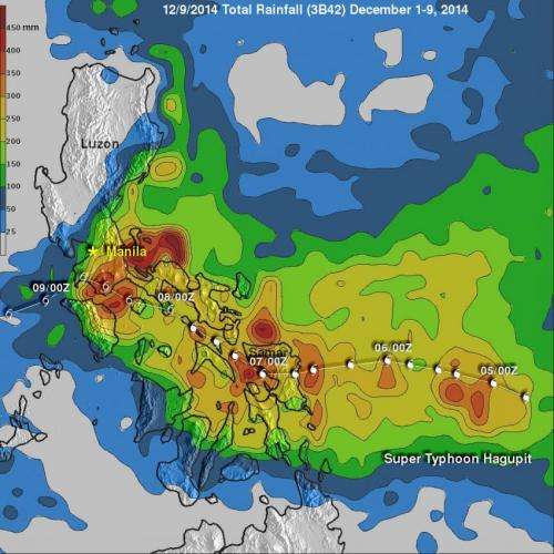
The Tropical Rainfall Measuring Mission or TRMM satellite, managed by NASA and the Japan Aerospace Exploration Agency gathered over a week of rainfall data on Hagupit. That rainfall data along with data from other satellites was compiled into an analysis to determine how much rain fell over various areas of the Philippines and surrounding areas.
On Dec. 8, the TRMM team at NASA's Goddard Space Flight Center in Greenbelt, Maryland performed a preliminary rainfall analysis and updated it on Dec. 9. The analysis of rainfall from Dec. 1-9, 2014) showed rainfall totals of over 450 mm (17.5 inches) in a few areas in the eastern Philippines near where Hagupit came ashore. Even greater rainfall totals of over 477 mm (18.7 inches) were analyzed over the open waters of the Philippine Sea east of Manila.
Manila received moderate to heavy rainfall but avoided extremely heavy precipitation as Hagupit (Ruby) moved past to the south of the capital. Rainfall amounts of over 200mm (almost 8 inches) were prevalent from southern Luzon through eastern Samar.
On Dec. 10 at 03:10 UTC (Dec. 9 at 10:10 p.m. EST), NASA's Terra satellite captured a view of Tropical Storm Hagupit in the South China Sea. In the visible image, Hagupit appeared to be curled up as thunderstorms surrounded the center, and extended in a wide band to the northeast of the center. Hagupit's center was almost in the middle of the South China Sea between the Philippines to the east and Vietnam to the west.

At 1500 UTC (10 a.m. EST), Hagupit's maximum sustained winds remained at 40 knots (46 mph/74 kph), the same strength they were on Dec. 9. Hagupit was centered near 13.6 north longitude and 114.7 east latitude, or about 533 nautical miles (613.4 miles/987.1 km) east-northeast of Ho Chi Minh City, Vietnam. The storm was moving to the west at 9 knots (10.3 mph/16.6 kph).
Hagupit is now predicted by the Joint Typhoon Warning Center to continue weakening and make landfall in southern Vietnam mid-day Dec. 11 (EST) or just after midnight local time in Vietnam. A Severe Tropical Storm Warning is currently in effect for southern Vietnam.
Provided by NASA's Goddard Space Flight Center


