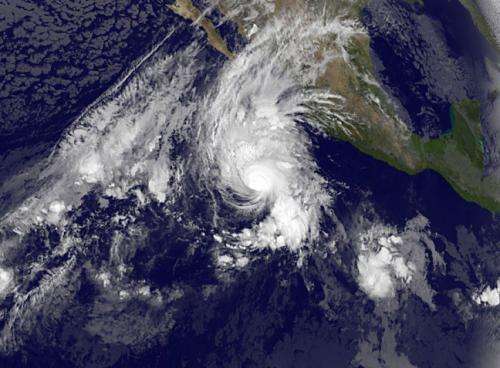
Hurricane Vance dwarfs developing low pressure area

NOAA's GOES-West satellite captured an image of Hurricane Vance and a much smaller developing low pressure area in the Eastern Pacific Ocean on Nov. 3. Vance's tropical-storm force winds extended to about 250 miles in diameter.
NOAA's GOES-West satellite captured an infrared image of the Eastern Pacific that showed Hurricane Vance was a couple of times larger than the developing low pressure area known as System 94E to the southeast of the hurricane. In the GOES image, taken Nov. 3 at 1200 UTC (7 a.m. EST/4 a.m. PST) clouds and showers extending from Vance's northern quadrant stretched over northwestern Mexico.
At 7 a.m. PST, the center of Hurricane Vance was located near latitude 15.3 north and longitude 110.6 west. That puts Vance's center about 490 miles (785 km) west-southwest of Manzanillo, Mexico. Vance was moving toward the north-northwest near 12 mph (19 kph). Vance is expected to turn north then north-northeast by Nov. 4. Maximum sustained winds were near 105 mph (165 kph) and weakening is expected to begin today.
Moisture spreading northward ahead of Vance is expected to produce rainfall totals of 4 to 8 inches with Isolated amounts near 12 inches through Wednesday over the states of Sinaloa, Nayarit and Durango in western Mexico. Rough ocean swells are expected along the coast of southwestern Mexico and Baja California Sur tonight and Nov. 4.
Forecaster Brown at the National Hurricane Center (NHC) noted that "Recent microwave images show that the inner core of Vance remains vertically aligned (stacked on top of each other), however, the outflow is becoming increasingly restricted over the southwestern portion of the circulation due to southwesterly shear." That vertical wind shear over Vance is forecast to dramatically increase during the next 24 to 48 hours which means that the storm is expected to weaken.
The NHC believes that Vance has peaked in intensity and will begin to rapidly weaken in the next couple of days as it curves to the coast near the border of Mexico and California.
Provided by NASA's Goddard Space Flight Center


