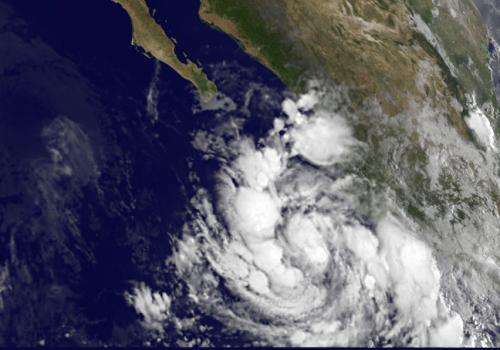
Satellite animation shows formation of Tropical Storm Simon off Mexico's southwestern coast

Mexico's western coast is again dealing with rain, wind and rough surf from another tropical storm. NOAA's GOES-West satellite saw the formation of Tropical Storm Simon on Oct. 2. A NASA animation of NOAA's GOES-West satellite imagery shows the development of Simon over three days.
Simon developed when the tropical low pressure area designated as System 90E organized by 5 p.m. EDT on Oct. 1 and became Tropical Depression 19-E. On Oct. 2 at 5 a.m. EDT, the depression strengthened into a tropical storm as was renamed "Simon." An animation of three days' worth of visible and infrared images created by the NASA/NOAA GOES Project at NASA's Goddard Space Flight Center in Greenbelt, Maryland showed those transitions.
Simon is the eighteenth named storm of the busy 2014 hurricane season in the east Pacific basin.
NOAA's GOES-West satellite has been providing continual coverage of the Eastern Pacific and has followed the development of Simon since it was System 90E. An infrared GOES-West satellite image taken on Oct. 2 at 13:15 UTC (9:15 a.m. EDT) showed Simon close to the western coast of Mexico.
The National Hurricane Center (NHC) noted on Oct. 2 that satellite images show curved bands of thunderstorms) became better established during the morning hours on Oct. 2, and the low-level center is estimated to be located beneath the strong thunderstorm activity.
NHC has not posted watches or warnings on Simon, but the tropical storm is large and close enough to shore to generate some heavy rainfall totals and rough surf.
Simon is expected to produce rainfall amounts of 3 to 5 inches with isolated amounts around 8 inches through Friday, Oct. 3 across Western Guerrero and Michoacan, Colima, western Jalisco and Nayarit in western Mexico. These rains could cause flash flooding and mud slides.
Simon is generating ocean swells and rough surf that is already affecting southwestern Mexico's coast. These swells are likely to cause life-threatening surf and rip current conditions.
At 5 a.m. EDT Simon had maximum sustained winds near 40 mph (65 kph) and some strengthening is forecast during the next two days. Simon's center was located near latitude 18.1 north and longitude 106.1 west. That's about 135 miles (215 km) west-southwest of Manzanillo, Mexico and Simon was moving toward the west-northwest near 10 mph (17 kph) and is expected to continue through Oct. 3. Simon's center is expected gradually move away from the southwestern coast of Mexico today.
The NHC's Forecaster Cangialosi noted that Simon is expected to strengthen during the next few days while the storm remains over warm water and within a fairly low wind shear and moist environment. Conditions will change in three days when the storm is expected to start on a weakening trend.
Provided by NASA's Goddard Space Flight Center


