NASA sees Hurricane Gonzalo head toward Bermuda

Tropical Storm Gonzalo intensified into a hurricane late on Monday, Oct. 14 and is expected to become a major hurricane as it moves toward Bermuda. NASA's Aqua satellite saw powerful thunderstorms within the center of the storm that were dropping heavy rainfall.
At 5 pm EDT, on Oct. 13 Gonzalo had become a hurricane. At that time, the center of the storm was just 20 miles southeast of St. Martin. The National Hurricane Center (NHC) noted that maximum sustained winds had increased to near 75 mph (120 kph) and additional strengthening was forecast. Gonzalo continued moving through the northern Leeward Islands overnight.
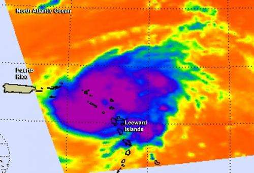
On Oct. 13 at 7:11 UTC (3:11 a.m. EDT) the AIRS instrument aboard NASA's Aqua satellite captured infrared data on Gonzalo that showed powerful thunderstorms around the center of circulation. Cloud top temperatures were colder than -63F/-52C.
On Oct. 14, a tropical storm warning remained in effect for the British Virgin Islands, Anguilla, St. Martin and St. Barthelemy.
On Oct. 14 at 5 a.m. EDT the eye of Hurricane Gonzalo was located near latitude 19.6 north and longitude 64.4 west. That's about 90 miles (145 km) north-northeast of St. Thomas. Gonzalo was moving toward the northwest near 13 mph (20 kph) and a turn toward the north-northwest is forecast by late Wednesday. On the forecast track the center of Gonzalo will move over the open Atlantic north of Puerto Rico today. Maximum sustained winds have increased to near 110 mph (175 kph) and additional strengthening is forecast during the next 48 hours. NHC said that Gonzalo is expected to become a major hurricane today.
The current forecast track from the National Hurricane Center takes Gonzalo over the island of Bermuda as a hurricane on Friday/Saturday.
Provided by NASA's Goddard Space Flight Center


