Tropical Storm Odile taken on by two NASA satellites

As Tropical Storm Odile continues to affect Mexico's west coast and stir up dangerous surf, NASA's TRMM and Aqua satellites provided forecasters information on clouds and rainfall in the coast-hugging storm. On September 12, A Tropical Storm Watch remained in effect from Manzanillo to Cabo Corrientes, Mexico.
Tropical Storm Odile formed on September 10, 2014 in the same area where Norbert formed.
Gathering Rainfall and Thunderstorm Height Information
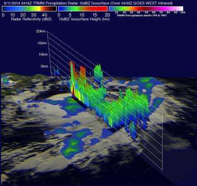
The Tropical Rainfall Measuring Mission or TRMM satellite flew over tropical storm Odile on September 11, 2014 at 0418 UTC (12:18 a.m. EDT) and collected rainfall data. A rainfall analysis made from TRMM's Microwave Imager (TMI) and Precipitation Radar (PR) data was overlaid on an enhanced infrared image of Odile's clouds from NOAA's GOES-West satellite to show where the rain was falling within that cloud shield (or the extent of the clouds). The coupled image showed that Odile was dropping rain at the extreme rate of over 196 mm (7.8 inches) per hour in powerful thunderstorms near Odile's center of circulation.
TRMM satellite radar reflectivity (which means the satellite reads signals bounced off the clouds and back to the satellite) data was used to create a simulated 3-D view (toward the east) of Odile's rainfall structure. The 3-D image showed the most intense thunderstorms were reaching altitudes of over 14.7 km (about 9.1 miles). The release of this much energy would normally lead to intensification but northeasterly vertical wind shear was dampening Odile. By September 12, that wind shear was relaxing, which will enable Odile to strengthen.
Taking the Cloud Top Temperatures
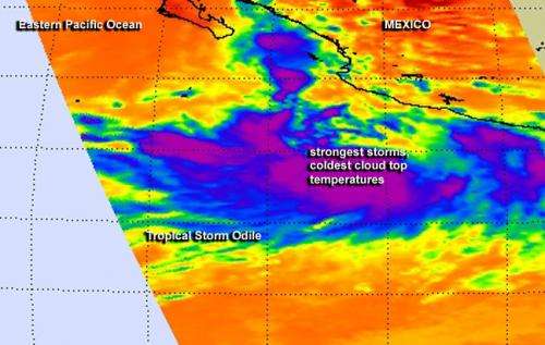
Later on September 11, NASA's Aqua satellite passed over Odile and the Atmospheric Infrared Sounder or AIRS instrument provided temperature data of Odile's cloud tops. The AIRS data confirmed the TRMM data, showing the coldest cloud tops in powerful thunderstorms circling the center of the storm. The AIRS data was false-colored to better show temperature differences at NASA's Jet Propulsion Laboratory in Pasadena, California. The coldest cloud tops were near -63F/-53C in storms circling Odile's center.

Odile's Location on September 12
At 8 a.m. EDT on September 12, Odile's maximum sustained winds were near 60 mph (95 kph) and some strengthening is forecast during the next 48 hours. The National Hurricane Center (NHC) advised that Odile could become a hurricane by tonight (Sept. 12). Odile's center was located near latitude 15.5 north and longitude 105.0 west. Odile is drifting toward the west near 2 mph (4 kph) and expected to move to the west-northwest and then northwest while picking up speed over the next day.
Dangerous Surf for Southwestern Mexico Over the Weekend
Odile's center is forecast will remain well offshore of the southwestern coast of Mexico through Sunday, September 14. Despite the center remaining off-shore, ocean swells are expected to affect the southwestern coast of Mexico over the next couple of days creating dangerous surf and riptides.
The NHC forecast calls for Odile to intensify into a hurricane and move in a northwesterly direction parallel to the west coast of Mexico. Odile is expected to follow close to the same track as hurricane Norbert and pass to the west of the southern tip of Baja California on Monday, September 15.
Provided by NASA's Goddard Space Flight Center


