NASA sees post-Tropical Cyclone Norbert fading near Baja California

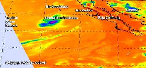
NASA's Aqua satellite passed over Tropical Storm Norbert on September 7 before it weakened to a post- tropical storm. The AIRS instrument aboard captured infrared data that showed a "sliver" of strong thunderstorms remained around the center of the waning storm.
When the Atmospheric Infrared Sounder or AIRS instrument gathered infrared data on Tropical Storm Norbert on Sept. 7 at 4:53 p.m. EDT, it showed only a small area of strong thunderstorms around the center where cloud top temperatures were near the -63F/-52C threshold for strong storms.
At that time, Norbert was still a tropical storm, with maximum sustained winds down to near 50 mph (85 kph) and weakening. Forecaster Cangialosi noted "A small patch of deep convection (thunderstorms) has been lingering just west of the center of Norbert during the last several hours. Although the cyclone is producing little deep convection, its circulation remains well established."
The National Hurricane Center (NHC) issued their final warning on the storm today, September 8 at 5 a.m. EDT (0900 UTC). Norbert had become post-tropical with maximum sustained winds near 40 mph (65 kph). The center of post-tropical cyclone Norbert was located near latitude 27.4 north and longitude 118.3 west. That's about 200 miles (320 km) west of Punta Eugenia, Mexico. The post-tropical cyclone is moving toward the northwest near 6 mph (9 kph) and a turn toward the north and northeast with a decrease in forward speed is expected during the next day or two. Norbert is expected to approach the west coast of the Baja California peninsula during the next couple of days. The estimated minimum central pressure is 1001 millibars.
Norbert is weakening rapidly and no longer qualifies as a tropical cyclone but is still causing rough surf along the Baja California coast. In addition, tropical moisture from Norbert's remnants are expected to continue to spread northward across northern Mexico and the southwestern United States which the NHC noted could result in heavy rains and life-threatening flash flooding in these area during the next day or two.
NHC forecasts continued gradual weakening and Norbert's dissipation in two to three days.
Provided by NASA's Goddard Space Flight Center


