NASA sees Tropical Storm Bertha leaving the Bahamas

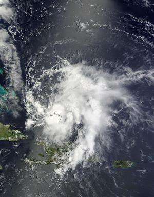
Tropical Storm Bertha took a "vacation" in the Bahamas on August 3 and NASA's Terra satellite captured an image of the storm that appeared be centered over "Crooked Island."
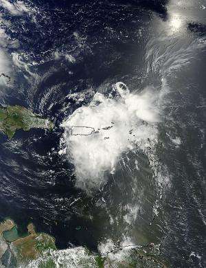
On August 2, before Bertha visited the Bahamas, the western half of the storm passed over Puerto Rico. A visible image captured by NASA's Terra satellite showed Bertha's clouds stretched from Puerto Rico east, over the British Virgin Islands. NOAA's National Weather Service office in San Juan, Puerto Rico reported 1.36 inches of rainfall from Bertha on August 2.
On August 3 at 15:35 UTC (11:35 a.m. EDT), the Moderate Resolution Imaging Spectroradiometer or MODIS instrument aboard NASA's Terra satellite captured a visible image of Tropical Storm Bertha over the Bahamas. The visible image showed powerful thunderstorms around Bertha's center, and southeast of the center. Those powerful storms southeast of the center were being pushed there from wind shear coming from the northwest.
Forecaster Stewart at the National Hurricane Center or NHC noted in the Discussion on Bertha on August 4 at 5 a.m. EDT, "Convection has been pulsing near the center, but the overall convective cloud pattern of Bertha has changed little since the previous advisory due to moderate northwesterly wind shear."

At 5 a.m. EDT (0900 UTC) the center of Tropical Storm Bertha was located near latitude 26.1 north and longitude 73.6 west. That puts the center of Bertha about 220 miles (350 km) east of Great Abaco Island, Bahamas. Bertha is moving toward the north near 16 mph (26 kph) and is expected to continue moving in that direction today according to NHC. NHC noted that Bertha will continue to move away from the Bahamas today and pass about midway between the U.S. east coast and Bermuda on August 5.
Reports from a NOAA hurricane hunter aircraft indicate that maximum sustained winds have increased to near 70 mph (110 kph) and additional strengthening is expected during the next day or two, so Bertha is expected to reach hurricane force later today, August 4 before weakening in a day.
The NHC noted that Bertha continues to move around the western edge of the stationary summertime big Bermuda-Azores high pressure system. Bertha is expected to continue moving around it in a clock-wise direction until Wednesday, August 6, when it is forecast to move northeastward into the mid-latitude westerlies (winds), keeping it off-shore from the U.S. East Coast.
Provided by NASA's Goddard Space Flight Center


