NASA sees massive Tropical Storm Lowell close enough to trouble Baja California

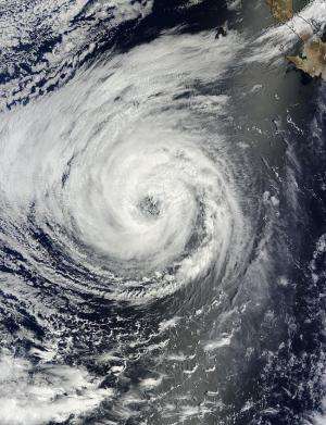
Although Tropical Storm Lowell is not over land the storm is large enough to cause strong ocean swells in Baja California. NASA's Terra satellite passed over Lowell and captured an image that shows how it dwarfed Tropical Storm Karina.
The National Hurricane Center noted that swells generated by Lowell will affect the west coast of the Baja California, Mexico, peninsula and portions of the coast of southern California through the weekend of August 23 and 24. These swells are likely to cause life-threatening surf and rip current conditions.
NASA's Terra satellite passed over Lowell when it was still a hurricane on August 21 at 18:45 UTC (2:45 p.m. EDT). The Moderate Resolution Imaging Spectroradiometer or MODIS instrument aboard Terra showed a large ragged eye-like feature in Lowell. By August 22, the cloud top temperatures in the thunderstorms surrounding the eye feature continued to warm and decrease in coverage from the previous day, indicating that the evaporation and uplift in the air is waning and thunderstorms are not getting as high in the atmosphere.
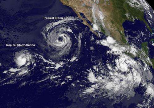
NOAA's GOES-West satellite captured a trio of tropical tempests in a train across the Eastern Pacific all in one image on Aug. 22 at 5 a.m. EDT with Lowell in the center. Tropical Storm Karina, dwarfed by Lowell's massive size, is located farthest west followed by Tropical Storm Lowell and Tropical Storm Marie, to the east, located near the southern coast of Mexico.

At 5 a.m. EDT (0900 UTC), Tropical Storm Lowell's maximum sustained winds dropped to 65 mph (100 kph) and gradual weakening is expected over the next couple of days. In fact, Lowell is expected to become a post- tropical storm over the weekend of August 23 and 24. The center of Tropical Storm Lowell was located near latitude 21.5 north and longitude 123.4 west. That's about 870 miles (1,395 km) west of the southern tip of Baja California. Lowell is moving toward the northwest near 8 mph (13 kph) and this general motion is expected to continue during the next couple of days.
Forecaster Daniel Brown at the National Hurricane Center noted "Lowell will be moving over progressively cooler waters and into a drier and more stable environment during the next several days. This should lead to gradual weakening, and Lowell is expected to become a gale-force post-tropical cyclone in a couple of days."
Provided by NASA's Goddard Space Flight Center


