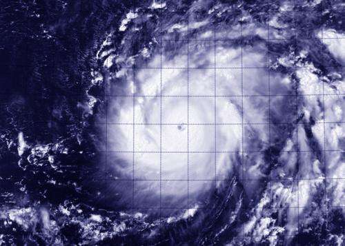
NASA sees Genevieve cross international date line as a Super-Typhoon

Tropical Storm Genevieve had ups and downs in the Eastern Pacific and Central Pacific over the last week but once the storm crossed the International Dateline in the Pacific, it rapidly intensified into a Super Typhoon. NASA-NOAA's Suomi NPP satellite captured of the storm.
When Suomi NPP flew over Genevieve on August 7 at 01:48 UTC the Visible Infrared Imaging Radiometer Suite (VIIRS) instrument aboard captured an infrared image of the storm. VIIRS collects visible and infrared imagery and global observations of land, atmosphere, cryosphere and oceans. VIIRS flies aboard the Suomi NPP satellite, which is managed by both NASA and NOAA.
The VIIRS image showed a symmetrical storm with a clear eye, about 15 nautical miles (17.2 miles/27.7 km) wide, surrounded by powerful thunderstorms.
On August 7 at 1200 UTC (8 a.m. EDT) Super-Typhoon Genevieve's maximum sustained winds were near 140 knots (161.1 mph/259.3 kph). Genevieve is a Category 5 typhoon on the Saffir-Simpson Hurricane Wind Scale. Genevieve was located near latitude 15.6 north and longitude 178.1 west, approximately 692 nautical miles (796 miles/1,282 km) west of Johnston Island.
The Joint Typhoon Warning Center (JTWC) noted "Genevieve has rapidly intensified over the past 24 hours." The storm's maximum sustained winds have increased by 75 knots (126.6 mph/ 138.9 kph), pushing the storm from 65 knots (74.3 mph/120.4 kph) to 140 knots (161.1 mph/259.3 kph).
When NASA's Tropical Rainfall Measuring Mission or TRMM satellite passed over Genevieve, data showed that there was a band of thunderstorms over the southern quadrant of the storm some 60 nautical miles (69 miles/111 km) thick.
The JTWC forecast calls for Genevieve to intensify with a peak of 145 knots (166.9 mph/268.5 kph) later on August 7. The forecast calls for Genevieve to maintain super typhoon strength over the next day and a half as it turns from a west-northwesterly track to a more northerly track over open ocean.
Provided by NASA's Goddard Space Flight Center


