NASA's Aqua satellite puts two eyes on Hurricane Bertha

Two instruments or "eyes" from NASA's Aqua satellite were peering at Hurricane Bertha in the North Atlantic Ocean shortly after it became the season's second hurricane. Bertha's hurricane status didn't last long as it weakened to a tropical storm today, August 5.
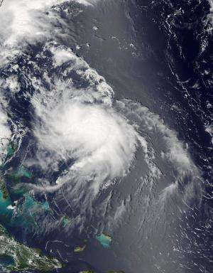
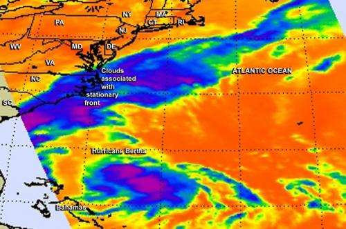
The Atmospheric Infrared Sounder or AIRS instrument aboard Aqua provides infrared data, while the Moderate Resolution Imaging Spectroradiometer or MODIS instrument provides visible data. Together, these instruments give scientists and forecasters a good look inside and outside of the storm to help determine what's happening.
At 11 a.m. EDT (1500 UTC) on August 4, reports from NOAA and air force hurricane hunter aircraft indicated that the maximum sustained winds had increased to near 80 mph (130 kph) and Bertha became a hurricane.
NASA's Aqua satellite passed over Hurricane Bertha at 1:47 p.m. EDT and the AIRS instrument gathered infrared data and cloud top temperature data on the storm, while the MODIS instrument snapped a visible image of the storm three minutes later. The MODIS image did not reveal an eye, and showed a thick band of thunderstorms wrapping into the center of circulation from the southeast.
When Aqua cast an infrared eye on the storm using the AIRS instrument, it provided information on cloud top heights and temperatures. The highest, coldest cloud top temperatures appeared around the center of circulation and in the eastern quadrant of the storm. The AIRS image also showed high clouds in a line off the U.S. East Coast from a stationary front.

On August 5 at 5 a.m. EDT (0900 UTC), Bertha had weakened back into a tropical storm. At that time Bertha's maximum sustained winds were near 65 mph (100 kph) over a small area northeast of the center.
The center of tropical storm bertha was located near latitude 33.4 north and longitude 72.9 west. That puts the center about 475 miles (765 km) west of Bermuda. Bertha was moving toward the north-northeast near 22 mph (35 kph) and the NHC expects a turn to the northeast and increase in forward speed. The minimum central pressure recently reported by a U.S. Air Force Reserve reconnaissance aircraft was 1005 millibars.
The National Hurricane Center has forecast gradual weakening over the next two days.
Provided by NASA's Goddard Space Flight Center


