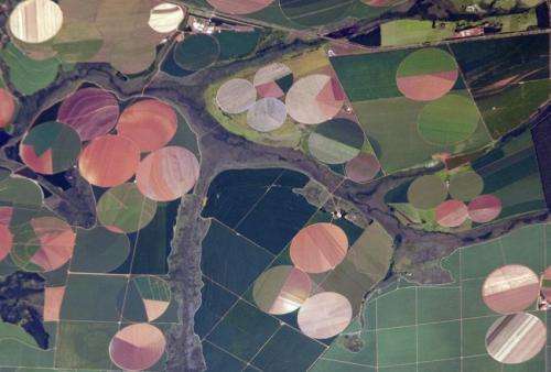
More people means more plant growth, NASA data shows

Ecologist Thomas Mueller uses satellite data to study how the patterns of plant growth relate to the movement of caribou and gazelle. The research sparked an idea: Would the footprint of human activity show up in the data?
Mueller, of the University of Maryland in College Park (now at the Biodiversity and Climate Research Center in Frankfurt) teamed up with university and NASA colleagues to find out. Their new analysis shows that on a global scale, the presence of people corresponds to more plant productivity, or growth.
Specifically, populated areas that have undergone intensive land use showed increasing plant greenness and productivity during the study period from 1981 to 2010. The research was published June 18 in Remote Sensing.
"Earth's land surface has been changed across very broad scales," Mueller said. "Human intervention has increased plant growth over large areas where intensification of agriculture has occurred."
The finding doesn't imply that relatively small areas with massive populations like New York City, with a high population density, are necessarily flourishing in increasingly abundant greenery. Rather, the study uses an existing classifications of the planet's land surface based on how it's impacted by people, including the dense settlements, villages and croplands that compose 28 percent of Earth's ice-free land surface. The rest of the land surface is categorized as forested, rangelands or wildlands.
The researchers used data from NOAA's Advanced Very High Resolution Radiometers (AVHRR), onboard a series of polar-orbiting satellites, and NASA's Moderate Resolution Imaging Spectroradiometer (MODIS) instruments, on the Terra and Aqua satellites, which produce a vegetation index that allows scientists to track changes in plant growth over large areas.
"We are fortunate to have 30 years of global vegetation greenness data from satellites to perform studies such as these," said Compton Tucker a co-author on the study at NASA's Goddard Space Flight Center in Greenbelt, Maryland.
The researchers found that the magnitude of changes in plant growth over the 29-year study period was different depending on the size of nearby population. Near areas defined as dense settlements – with about 500 people per square kilometer – the vegetation index increased by 4.3 percent. That's less than near villages, where the vegetation index increased by almost 6 percent. "More intensive agriculture occurs in these rural areas," Tucker added.
In short, areas with a human footprint have seen plant productivity increase. In contrast, areas with a minimal human footprint – rangelands and wildlands – saw close to no change.
Next, the team used a statistical analysis to estimate the relative importance of the various causes of changes in productivity. They showed that human-caused factors such as land use, nitrogen fertilization and irrigation accounted for much of the growth changes since 1981 in the areas studied.
The study follows on the heels of related research that showed the impact of climate on land plants at higher northern latitudes, where winter temperatures restrict the growing season, which researchers called the "warmer Earth, greener north" phenomenon. Agricultural areas were excluded from the higher northern latitude studies. "We now know that in addition to warmer climate at higher northern latitudes, human land use at lower latitudes also has a detectable, global footprint on Earth's vegetation growth," Tucker said.
Provided by NASA's Goddard Space Flight Center


