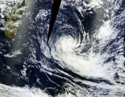
NASA satellite sees Tropical Cyclone Fobane spinning down

Tropical Cyclone Fobane continues to be battered with increasing vertical wind shear as it moves southward through the Southern Indian Ocean. NASA's Aqua satellite passed overhead and saw the bulk of precipitation and bands of thunderstorms were south of the center.
On Feb. 12 at 0900 UTC/4 a.m. EST, Tropical Cyclone Fobane had maximum sustained winds near 45 knots/51.7 mph/83.3 kph. Fobane was centered near 27.6 south latitude and 64.7 east longitude, about 596 nautical miles southeast of Port Louis, Mauritius. Fobane is moving to the south-southwest at 11 knots/12.6 mph/20.3 kph.
The Moderate Resolution Imaging Spectroradiometer or MODIS instrument aboard NASA's Aqua satellite captured a visible image of Tropical Cyclone Fobane on Feb. 12 at 0530 UTC/12:30 a.m. EST as it continued spinning down in the Southern Indian Ocean. The image showed a tightly-wrapped core and still appears well-organized. Bands of strong thunderstorms appear in the southwestern quadrant of the storm.
The Joint Typhoon Warning Center or JTWC looked at features stacked over Fobane in different layers of the atmosphere. JTWC noted that an upper level low pressure area embedded in a mid-latitude trough (elongated area of low pressure) is situated over Fobane's low-level center. Because of that upper-level low, convection and thunderstorm development has been stifled over the last day and a half, as it has created strong vertical wind shear between 20 to 30 knots/23.0 to 34.5 mph/37.0 to 55.5 kph) near the low-level center of Fobane. In addition to the upper-level atmospheric cocktail weakening Fobane, the storm is also moving into cooler sea surface temperatures which will weaken it more.
The JTWC expects Fobane to dissipate in the next couple of days.
Provided by NASA's Goddard Space Flight Center


