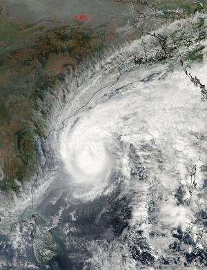
NASA sees Tropical Cyclone Madi nearing India's east coast

Tropical Cyclone Madi has maintained its tropical storm-force strength over 24 hours as it neared the coast of east central India on December 10. NASA's Aqua satellite flew overhead and provided a clear picture of the storm's proximity to the coast.
NASA's Aqua satellite passed over the western North Indian Ocean on December 10 at 07:45 UTC/2:45 a.m. EST. As it flew overhead from its orbit in space, the Moderate Resolution Imaging Spectroradiometer or MODIS instrument captured a visible image of the storm. The MODIS image showed an elongated system with no visible eye. The clouds of the storm's northwestern quadrant were skirting the coast. The lowest cloud top temperatures were about -75C.
At 1500 UTC/10 a.m. EST, Tropical cyclone Madi was centered near 15.1 north latitude and 84.9 west longitude, about 295 nautical miles/339.5 miles/ 546.3 km east-northeast of Chennai, India. Madi's maximum sustained winds were near 60 knots/69 mph/111.1 kph. Tropical storm-force winds extend 90 nautical miles/103.6 miles/ 166.7 km from the center, so it is a small tropical storm. Madi was moving to the southwest at 5 knots/5.7 mph/9.2 kph and continued to move to shore. The Joint Typhoon Warning Center noted that Madi was generating 25 foot/7.6 meter-high seas and generating rough surf along the east central India coastline.
Satellite imagery shows that wind shear is now affecting the low-level circulation center of the storm. That wind shear is acting to separate the upper and lower levels of the circulation center which will weaken the storm. In order for the storm to maintain strength the different levels of circulation need to be stacked on top of each other. In addition to the wind shear, cold, dry air is wrapping into the system, weakening it further.
Madi is now moving on a southwesterly course as a result of a low-to-mid-level subtropical ridge (elongated area) of high pressure that has been building up over India. The storm will make landfall along the southeastern coast of the state of Tamil Nadu sometime on December 12.
Provided by NASA's Goddard Space Flight Center


