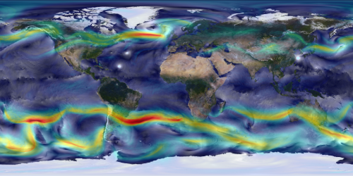
Image: A portrait of global winds

High-resolution global atmospheric modeling provides a unique tool to study the role of weather within Earth's climate system. NASA's Goddard Earth Observing System Model (GEOS-5) is capable of simulating worldwide weather at resolutions as fine as 3.5 kilometers.
This visualization shows global winds from a GEOS-5 simulation using 10-kilometer resolution. Surface winds (0 to 40 meters/second) are shown in white and trace features including Atlantic and Pacific cyclones. Upper-level winds (250 hectopascals) are colored by speed (0 to 175 meters/second), with red indicating faster.
This simulation ran on the Discover supercomputer at the NASA Center for Climate Simulation. The complete 2-year "Nature Run" simulation—a computer model representation of Earth's atmosphere from basic inputs including observed sea-surface temperatures and surface emissions from biomass burning, volcanoes and anthropogenic sources—produces its own unique weather patterns including precipitation, aerosols and hurricanes. A follow-on Nature Run is simulating Earth's atmosphere at 7 kilometers for 2 years and 3.5 kilometers for 3 months.
Provided by NASA


