NASA saw Henriette fading and two struggling lows behind

Once a hurricane, Henriette weakened to a depression in the Central Pacific Ocean on Sunday, Aug. 11 and dissipated by Aug. 12 as two other low pressure areas continued to struggle. NASA's TRMM satellite noticed that Henriette's weakening trend began on Aug. 8.
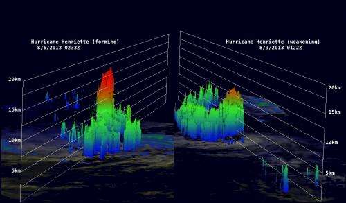
NASA's Tropical Rainfall Measuring Mission or TRMM satellite flew over Henriette again on August 9, 2013 at 0122 UTC (~ 4 p.m. local time). During a TRMM orbit overpass on August 8, 2013 at 1709 UTC. (1:09 a.m. EDT), Henriette's eye that was visible but disappeared from view on Aug. 9.
At NASA's Goddard Space Flight Center in Greenbelt, Md. 3-D images were created showing TRMM data on Aug. 6 and Aug. 9 using Precipitation Radar (PR) data. On Aug. 6 rain was falling at a rate of over 161mm (~6.3 inches) per hour near the center of the hurricane and the tremendous amount of energy being released by towering thunderstorms in Henriette's forming eye was evident with tops reaching almost 16.75 km (~10.41 miles). In contrast, TRMM PR data from Aug. 9 showed thunderstorms near Henriette's center were found to reach heights of less than 12 km (~7.5 miles) indicating the storm had weakened. Henriette dissipated south of Hawaii early on Aug. 12.
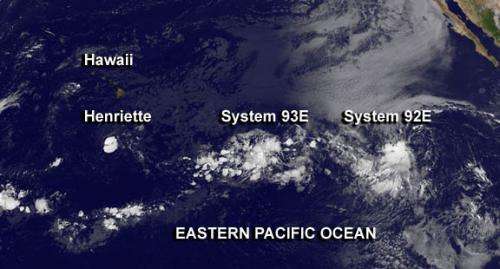
On Monday, Aug. 12, two areas of low pressure are being watched for possible development in the Eastern Pacific Ocean. They are located east of where Henriette dissipated are referred to as System 93E and System 92E.
The elongated area of low pressure or trough called System 93E is about 1,300 miles east-southeast of Hawaii near 13 north and 136 west. It is producing disorganized showers and thunderstorms and it is moving westward at 10 to 15 mph. This system has a low chance, just 10 percent, of becoming a tropical cyclone during the next two days.

Farthest east is low pressure System 92E, near 13.2north and 123.6 west, about 1,125 miles southwest of Cabo San Lucas, Mexico. That low is also producing disorganized showers and thunderstorms, but has a slightly better chance of developing first. The National Hurricane Center gives System 92E a 20 percent chance for becoming a tropical depression in the next 2 days.
Provided by NASA's Goddard Space Flight Center


