Satellite sees Flossie fizzle fast

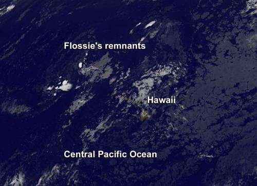
Tropical Depression Flossie fizzled fast on July 30 in the Central Pacific Ocean. Satellite imagery on July 31 showed remnant clouds northwest of the Hawaiian Island chain.
NOAA's Central Pacific Hurricane Center issued the final advisory on the remnants of Tropical Depression Flossie on July 30 at 1500 UTC/11 a.m. EDT. At that time Flossie's remnant low pressure area was centered near 22.3 north latitude and 159.8 west longitude, about 140 miles west-northwest of Honolulu, Hawaii. The low pressure area was still moving to the west-northwest at 16 knots and the maximum sustained winds had dropped to 25 knots.
On July 31 at 1500 UTC (11 a.m. EDT) NOAA's GOES-15 or GOES-West satellite captured infrared imagery of the remnants of what was Tropical Depression Flossie northwest of Niihau and Kauai in the Hawaiian Island chain. The remnant clouds appear scattered and almost ghost-like on the infrared satellite imagery. The image was created by NASA's GOES Project at NASA's Goddard Space Flight Center in Greenbelt, Md.
According to Hawaiinewsnow.com, almost 10,000 customers lost power across the Valley Isle and the entire island of Molokai was powerless for about 45 minutes Monday evening, July 29. Clean-up of trees and branches downed by Flossie's winds continues today, July 31 as the memory of Flossie fades.
Provided by NASA's Goddard Space Flight Center


