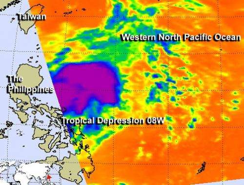
NASA sees newborn Tropical Depression 08W in infrared

Infrared satellite data helps identify cloud top and sea-surface temperatures, and the AIRS instrument aboard NASA's Aqua satellite captured those when it flew over Tropical Depression 08W in the western North Pacific Ocean. Tropical Depression 08W formed east of the Philippines.
The Atmospheric Infrared Sounder or AIRS instrument took an image of 08W on July 16 at 04:35 UTC (12:35 a.m. EDT). The AIRS infrared image showed a large area of strong thunderstorms appeared mostly east of the center of 08W's circulation. Those thunderstorms had cloud top temperatures near 210 K (-81.6 F/-63.1 C). Despite the flaring convection (rising air that form the thunderstorms that make up the tropical cyclone), the low-level circulation center appeared to be struggling to organize.
AIRS data also showed sea surface temperatures near 300 K (80.3 F/26.8C) in the vicinity of Tropical Depression 08W. Those temperatures are warm enough to support the depression and help it intensify.
On July 16, warnings were in effect as Tropical Depression 08W approached the northern Philippines. The Philippines' public storm warning signal #1 is in effect for the Luzon provinces of Aurora, Quirino, Isabela, Ifugao, Mt. Province, Abra, Kalinga, Apayao, Ilocos Norte and Sur, Cagayan, Calayan and Babuyan Group of Islands and Batanes Group of Islands.
At 1500 UTC (11 a.m. EDT) on July 16, Tropical depression 08W, known in the Philippines as "Isang," had maximum sustained winds near 25 knots (28.7 mph/46.3 kph). 08W's center was located near 16.8 north latitude and 123.3 east longitude, or 182 miles east-northeast of Manila, Philippines. Tropical Depression 08W is moving to the northwest at 9 knots (10.3 mph/16.6 kph).
08W is expected to intensify into a tropical storm and track to the northwest, through the Strait of Luzon. The depression is expected to graze the northernmost Philippines, track just west of Taiwan and move northward over southeastern China before turning into the Yellow Sea. The depression will bring heavy rains and gusty winds to all of those areas and residents should be on guard for flooding.
Provided by NASA's Goddard Space Flight Center


