NASA satellites see Eastern Pacific's hurricane Cosme weaken

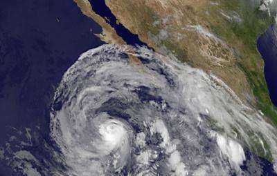
NASA's Tropical Rainfall Measuring Mission or TRMM satellite captured the third named Eastern Pacific tropical cyclone as it grew to hurricane strength. Hurricane Cosme was bringing those winds to Clarion Island, Mexico on June 26 and its northernmost clouds extended over southern Baja California.
On Sunday, June 23, the third tropical depression of the Eastern Pacific Ocean season formed about 500 miles south of Manzanillo, Mexico. Tropical Depression 3E was located near 11.8 north latitude and 103.8 west longitude. By 5 p.m. EDT on Monday, June 24, the depression strengthened into a tropical storm and was named Cosme. Cosme was located near 12.8north and 105.2 west, about 435 miles (695 km) south of Manzanillo, Mexico. At that time, Cosme's maximum sustained winds were near 40 mph (65 kph).
On Tuesday, June 25, Cosme became a hurricane. NASA's Tropical Rainfall Measuring Mission (TRMM) satellite flew over Cosme at 1346 UTC (9:46 a.m. EDT) shortly before it was upgraded to a hurricane. A rainfall analysis from TRMM's Microwave Imager (TMI) and Precipitation Radar (PR) instruments showed the location of Cosme's forming eye.
On Wednesday, June 26 at 5 a.m. EDT, Hurricane Cosme was battering Clarion Island, Mexico. It was centered just 15 miles (25 km) east of the island, near 18.4 north and 114.5 west. Cosme's maximum sustained winds were near 80 mph (130 kph). Cosme was moving to the west-northwest near 14 mph (22 kph) and is expected to continue in this direction over the next several days. It had a minimum central pressure of 983 millibars. NOAA's GOES-15 satellite captured an image of Hurricane Cosme when its eye was very close to Clarion Island, Mexico and its maximum sustained winds were near 80 mph. The image showed the northernmost extent of Cosme's clouds were covering the southern Baja California peninsula. NOAA manages GOES-15, and NASA's GOES Project at NASA's Goddard Space Flight Center in Greenbelt, Md. created the image that showed Cosme's large reach.
The National Hurricane Center expects that Cosme will continue weakening through the day and drop to tropical depression status sometime on June 27.
The largest danger to Mexico's Pacific coast will be large swells from Acapulco to Los Mochis and the southern Baja California Peninsula.
Provided by NASA's Goddard Space Flight Center


