NASA sees Cyclone Rusty threatening Western Australia

Tropical Cyclone Rusty formed on Feb. 24 and has already caused warnings up for the residents of northwestern West Australia, including Port Hedland. NASA's Terra satellite saw that outer bands of this quick-forming tropical cyclone were already affecting land.
The Australian Bureau of Meteorology (ABOM) has posted cyclone warnings and a yellow and blue alert for Western Australia as Rusty approaches for a landfall. A Cyclone Warning is in effect from Broome to Mardie, and adjacent inland areas of the Pilbara, including Marble Bar, Nullagine and Millstream. A Cyclone Watch is in effect for adjacent inland areas of the Pilbara including Tom Price, Newman and Telfer.
A Yellow Alert is in effect for communities between Wallal and Whim Creek, including Pardoo, De Grey and Port Hedland. ABOM has also issued a Blue Alert for communities between Broome and Wallal including Broome and Bidyadanga, between Whim Creek and Mardie, including Karratha and extending to adjacent inland areas including Marble Bar, Nullagine and Millstream.
On Sunday, Feb. 24, soon after Rusty formed warnings were already being posted. At 1200 UTC (7 a.m. EST) on Feb. 24, Rusty's maximum sustained winds had quickly climbed to near 60 knots (69 mph/111 kph). Rusty's center was located near 17.7 south and 118.3 east, about 160 nautical miles from Port Hedland, Australia and was slowly moving to the south-southwest
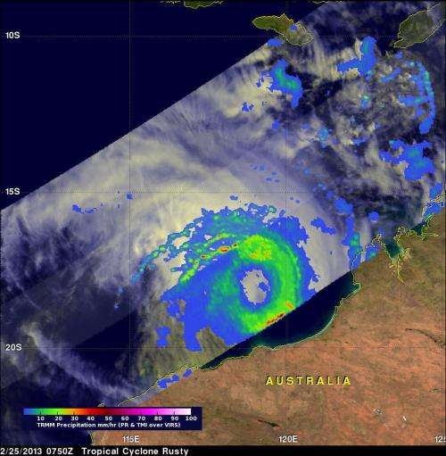
Microwave satellite data on Feb. 24 showed that Rusty was consolidating rapidly and had already developed a 20-nautical mile wide eye despite being a tropical storm.

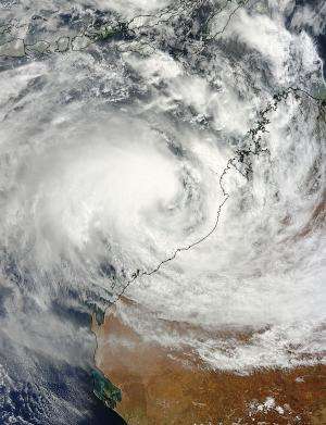
On Feb. 25 at 0215 UTC (9:15 p.m. EST, Feb. 24) the Moderate Resolution Imaging Spectroradiometer (MODIS) instrument aboard NASA's Terra satellite captured a visible image of Cyclone Rusty closing in on the northwestern coast of Western Australia. Rusty's outer band of thunderstorms stretched from Broome to Port Hedland. Satellite data showed that the bands of thunderstorms have intensified and are wrapping more tightly into the low level circulation canter than they did 24 hours prior.
On Feb. 25 at 0900 UTC (4 a.m. EST/ 5 p.m. local time WST), Cyclone Rusty's maximum sustained winds were near 65 knots (74.8 mph/120.4 kph). Rusty was located near 18.4 south latitude and 119.0 east longitude and moving to the southeast at 5 knots (5.7 mph/9.2 kph). At 1500 UTC (10 a.m. EST/11:00 p.m. WST local time) Tropical Cyclone Rusty was estimated to be 210 kilometers north northeast of Port Hedland, according to the Australian Bureau of Meteorology. Forecasters at the Joint Typhoon Warning Center caution that Rusty is expected to intensify quickly over the next day because of warm waters and low wind shear.
Rusty is a large tropical cyclone and its slow movement is likely to result in higher than usual rainfall in the Pilbara and western Kimberley coasts. Because of the storm's slow track, heavy rainfall and flooding are likely over the next couple of days. Very rough surf, high waves and coastal erosion are also likely as Rusty slowly heads for landfall. For updated warnings, watches and alerts from the ABOM, visit: http://www.bom.gov.au/australia/warnings/index.shtml.
The Joint Typhoon Warning Center now projects that landfall will occur sometime near 1800 UTC (1 p.m. EST/U.S.) on Feb. 26 or 2 a.m. WST local time on Feb. 27, just east of Port Hedland.
Provided by NASA's Goddard Space Flight Center


