Storms in the machine

NASA researchers are constructing a statistical typhoon model that can quickly generate millions of synthetic typhoons from birth through termination. Their work could provide new details about the climate of Earth, and what the future may hold for life on our planet.
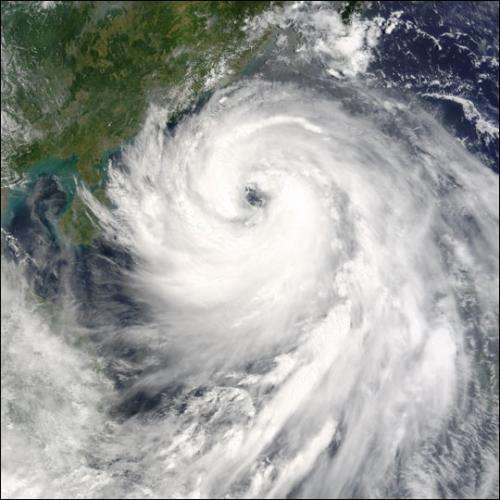
The year is 1975, and a dark cloud is looming off the coast of Taiwan. With little warning, the storm comes crashing ashore with winds of over 150 miles per hour. The 'super typhoon' tears its way across the island - but the real horror comes when it makes its way onto Mainland China. Although weakened by its journey over the mountains of Taiwan, typhoon Nina lashes inland China with torrential rain. This results in the catastrophic failure of the Banquiao Dam. Floods sweep over the land, claiming over 171,000 lives and causing billions of dollars in damage.
In 2011 alone, by some estimates the cost of "Typhoon Season" in the Pacific was over 4 billion US dollars and total deaths passed 1700. Many of the most populous cities in the world now line the coastal regions of the Asian mainland, Japan, the Philippines and other Pacific island states. In China alone, some 250 million people live in areas threatened by such storms. Every year, the lives of millions upon millions of people are in harms way.
Asian Brew
When a typhoon begins brewing in the Pacific, numerical weather modeling is used to forecast how the storm will evolve in the following days. These storms can develop with ferocious speed and quickly sweep toward populated areas.
Unfortunately, a few days warning is not enough to prevent the death and destruction that follows.

Local governments, disaster management groups and the insurance industry would benefit from more time to plan and prepare. In fact, it takes these institutions years to develop effective methods for dealing with massive typhoons. They need to be able to answer questions like: what are the odds that a given coastal city will suffer a major typhoon strike in the next year? Or the next five years? How are these odds affected by our changing climate? How can past typhoon observations, trends, and fluctuations in climate be used to inform current and future policies in coastal regions? A new computer model may have some answers.
Typhoons in the Machine
Two researchers from NASA and Columbia University, Emmi Yonekura and Tim Hall, are constructing a statistical typhoon model that can quickly generate millions of synthetic typhoons from birth through termination, and whose statistical properties match those of the hundreds of historical documented typhoons. They then use the synthetic set to estimate local Asian landfall rates with a precision much higher than could be obtained directly from historical landfalls. In its current stage the model simulates typhoon formation and propagation and their dependencies on a natural climate pattern known as "El Niño/Southern Oscillation" (ENSO).

ENSO - called El Niño or La Niña depending on phase - is the Earth's dominant year-to-year climate variability. The ENSO cycle is irregular, repeating every 2 to 7 years. Put simply, ENSO is the east-west sloshing of warm tropical Pacific surface waters. ENSO not only affects Pacific-sector weather, but also has global influence on temperature, wind patterns, and rainfall.

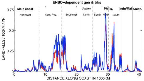
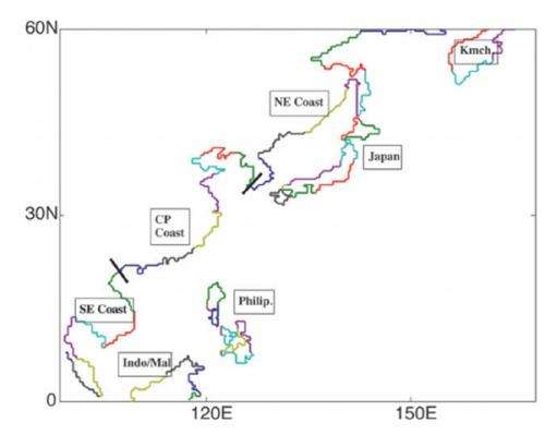
Using carefully optimized statistical analysis of past typhoon behavior, Yonekura and Hall are able to quantify how the number of typhoons forming each year in the north Pacific is dependent on ENSO. Additionally, they have been able to gather data on where in the north Pacific the storms form and how, on average, the storms propagate. The researchers use these storms' dependencies on ENSO in their model to generate tens of thousands of typhoons in each of several fixed ENSO states spanning the observed range of ENSO. This allowed them to compute landfall rates of typhoons at high spatial resolution along Asian coastlines as a function of ENSO phase.
Predicting the future
The overall annual number of typhoons changes only modestly with ENSO, but there are significant changes in the shape of typhoon tracks and the dominant regions of typhoon formation. El Niño typhoons propagate further westward before re-curving northeast, a feature that increases their odds of making landfall. However, El Niño typhoons also form further eastward, away from the coast, which reduces their landfall odds. The combined effect is an overall reduction in landfall during El Niño and an increase during La Niña (although there is considerable variation along the coast). Southern China and Southeast Asia experience the largest increase of landfall in La Niña, while the Philippines show no overall ENSO sensitivity and even regions of opposite sensitivity.
As the Pacific nations brace for the 2013 typhoon season, meteorologists will ply their skills to forecast the evolution over days of particular storms already formed. Thanks to the research at NASA/GISS and Columbia University, we may soon have a new weapon in our arsenal for predicting the areas and climate states with the greatest long-term risk for major typhoon strikes.
More information: Sovacool, B.K. 2008. The costs of failure: A preliminary assessment of major energy accidents, 1907-2007, Energy Policy, 36, 1802-1820, doi:10.1016/j.enpol.2008.01.040.
Wikipedia 2012. 2011 Pacific typhoon season. Available at en.wikipedia.org/wiki/2011_Pacific_typhoon_season. Accessed 19 Nov. 2012.
Liu, D., L. Pang, and B. Xie, 2009. Typhoon disaster in China: prediction, prevention, and mitigation. Nat. Hazards, 49, 421-436 doi:10.1007/s11069-008-9262-2.
Yonekura, E., and T.M. Hall, 2011. A statistical model of tropical cyclone tracks in the Western North Pacific with ENSO-dependent cyclogenesis, J. Appl. Meteor. Climatol., 50, 1725-1739, doi:10.1175/2011JAMC2617.1.
Yonekura, E., and T.M. Hall, 2012. Typhoon tracks and ENSO: Separating genesis and track propagation effects, J. Appl. Meteorol. Climatol., submitted.
Provided by Astrobio.net


